
CMOR Mapping West Gulf of Mexico f/Raymarine

Shipping (3PM)
Within 30 days
CMOR Mapping West Gulf of Mexico f/Raymarine Product Description
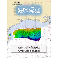
West Gulf of Mexico for Raymarine
The West Gulf Of Mexico CMOR Card includes coverage offshore of western Louisiana and Texas: If your looking to deep drop for grouper, tilefish and swords or find the humps that push the bait and pelagics to the surface, this is a must have chart for your boat!
The Coverage includes but is not limited to the list below.
- Deep water coverage from approximately 250ft- 12,000ft throughout the East Gulf of Mexico
- 270 sq mile nearshore Area offshore of Laguna Madre
- The Texas “HillTops”
- East Break and Little Drop
- West Flower Garden Banks
- East Flower Garden Banks
- Shelf Banks and Domes
- Most deep water Basins, Ridges, escarpments, and Domes in the Western Gulf
CMOR Mapping bathymetry arms you with more and better data than anybody else on the water.
NOAA Chart 411 and 11006 are included in the background.
All CMOR Cards come on Micro SD cards with a standard SD adapter included.
CMOR Compatible Devices:
Raymarine
CMOR cards are compatible with all units capable of running the Lighthouse II and Lighthouse 3 interfaces. In order to support CMOR Mapping, units must have at least v17 software installed. Units include:
- Axiom Series
- Axiom Pro
- Hydbrid Touch
- aSeries
- cSeries
- eSeries
- eS Series
- gS Series
- Dragonfly Series
CMOR Mapping Western Gulf of Mexico CMOR Card for Raymarine
Model: WGOM001R- The West Gulf Of Mexico CMOR Card includes coverage offshore of western Louisiana and Texas: If your looking to deep drop for grouper, tilefish and swords or find the humps that push the bait and pelagics to the surface, this is a must have chart for your boat!
- Deep water coverage from approximately 250ft- 12,000ft throughout the East Gulf of Mexico
- 270 sq mile nearshore Area offshore of Laguna Madre
- The Texas "HillTops"
- East Break and Little Drop
- West Flower Garden Banks
- East Flower Garden Banks
- Most deep water Basins, Ridges, escarpments, and Domes in the Western Gulf
- CMOR Mapping bathymetry arms you with more and better data than anybody else on the water.
- NOAA Chart 411 and 11006 are included in the background.
- All CMOR Cards come on Micro SD cards with a standard SD adapter included.
CMOR cards are compatible with all units capable of running the Lighthouse II and Lighthouse 3 interfaces. In order to support CMOR Mapping, units must have at least v17 software installed. Units include: Axiom Series, Axiom Pro, Hydbrid Touch, aSeries, cSeries, eSeries, eS Series gS Series, Dragonfly Series
The best diving and bottom-fishing spots are the ones that don’t show up on the paper or digital charts and aren’t marked on commercially available fishing maps. Instead, they’re the forgotten wrecks, the isolated reefs, the ledges hidden between the contour lines — places you spend hundreds of hours on the water and burn thousands of dollars in fuel to find.
Now, though, CMOR Mapping’s chartplotter-compatible bathymetry reveals those spots for the first time. With resolution as high as 1 meter (each pixel represents a single square meter of bottom) and coverage of the entire bottom, you see every bump in remarkable detail. Just as importantly, you see the areas of featureless underwater desert, where you don’t need to spend your time looking.
Most fishing maps and charts that show depth contour lines interpolate those lines from historical sounding data. In other words, the contours are drawn by looking at the measured depth at a number of points and then making educated guesses about what the bottom looks like between those points. In many cases, the results are fairly accurate. But isolated features — a 5-foot ledge between two soundings a quarter mile apart, for example — are easily missed.
In contrast, CMOR Mapping data is the result of methodical surveys with high-resolution echosounders. There is no interpolation, no guesswork, and no unverified "hotspots" reported by local captains. All you see is a complete, accurate, and highly detailed representation of the bottom, including many features that are not shown on any other chart or fishing map.
The value of CMOR Mapping imagery when fishing or diving a new area is obvious — instead of relying on "public numbers" or feeling your way along looking for more productive spots, you’re immediately in the game.
Not only will you see features you never knew existed — things you may have run right past a hundred times — but you’ll also see known features in game-changing detail. Large, dispersed artificial reef areas, for example, come into an entirely new level of focus, with each individual piece of structure clearly visible.
Frequently Asked Questions (FAQ) About CMOR MAPPING W GULF OF MEXICO F/ RAYMARINE
Who is the CMOR Mapping?Who is the CMOR Mapping?
Save $519 when you buy the CMOR Mapping West Gulf of Mexico f/Raymarine for only $180 from NVN Marine! Same day shipping before 3pm.
CMOR Mapping West Gulf of Mexico f/Raymarine Videos
CMOR Mapping West Gulf of Mexico f/Raymarine Technical Specifications
| Type: | |
|---|---|
| Vendor: |
CMOR Mapping |
| Weight: |
0.1 lb |
| User Guide: |
CMOR Mapping West Gulf of Mexico f/Raymarine User Reviews
CMOR Mapping West Gulf of Mexico f/Raymarine Shipping & Return
| Shipping Weight: |
0.1 lb |
|---|---|
| Box Sizes: |
1.00 (h) x 5.00 (w) x 8.00 (l) |
| Cubic Feet: |
40.0 |
| Returnable: |
Yes |
| USPS First Class: |
Yes |
For detailed shipping policy please check our Shipping Policy and you can find our Return and Refund Policy here.