
CMOR Mapping North Florida, Georgia & South Carolina f/Raymarine
- "Not Applicable."
- "This card replaces the North East Florida and Oculina\/East Canaveral and now contains Georgia and the majority of South Carolina."
- "The north FLORIDA\/GEORGIA\/SOUTH CAROLINA Card covers of some of the best fishing, diving, and deep dropping spots in the Atlantic Ocean."
- "NOAA Charts are included in the background."

Shipping (3PM)
Within 30 days
CMOR Mapping North Florida, Georgia & South Carolina f/Raymarine Product Description
North Florida, Georgia & South Carolina for Raymarine
This card replaces the North East Florida and Oculina/East Canaveral and now contains Georgia and the majority of South Carolina.
The North Florida, Georgia and South Carolina Card covers of some of the best fishing, diving, and deep dropping spots in the Atlantic Ocean.
A Few of the Areas Covered:
- 100 Fathom Curve (57nm ESE of Georgetown SC)
- Charleston Bump and many surrounding areas (swordfish mecca)
- Georgetown Hole (47nm SSE Georgetown SC)
- 100 / 400 area (59nm SE Little River Inlet, SC)
- Winyah Scarp (43nm SE Georgetown SC)
- “THE LEDGE” (47nm ESE Charleston SC)
- River Ledge 75ft depth (18.8nm SE Charleston SC)
- Charleston Natural Bottom 41-47ft depth (9nm SE Charleston Harbor)
- Charleston Shipping Channel
- Deep Drop / Swordfish Bottom 1331 to 1978ft 78nm SE Charleston SC
- Edisto Banks (50nm SE Edisto Island, SC)
- Southern Edisto Banks (8nm SW of Edisto Banks)
- The “DELI” (63nm SE of Hilton Head Island)
- Triple Ledge (66nm SE Savannah Georgia )
- Grays Reef Ledge 50-60ft depth (18nm SE Sapelo Sound GA)
- Natural Ledges Depths 60-65ft (18.5nm ESE St. Chatherines Sound)
- Anchor Ledge 75-82ft depth (26nm SE Ossabaw Sound)
- “GROUPER” ledges 120-128ft Depth (49nm East St. Simons)
- “KBY” Artificial Reef (9nm ENE Fernandina Beach, FL)
- SCAMP CITY 140-148ft depth (64nm East St. Mary's River)
- “FB” Natural Ledges (14nm ESE Fernandina Beach FL)
- Nassau Mud Humps (6nm E Nassau Sound)
- Jax Live Bottom 81-86ft deep (17nm E St. Johns River)
- Mayport Jetties and St. Johns River
- Pinnacles 1450 ft sand – 1351 ft top (43nm E Cape Canaveral)
The northern section of the original NEFL data starts due east of Fernandina Beach in an area locals call the R4 Navy Tower Bottom. Depths range from 100' to 2,200'.
The southern section of the original NEFL data starts east of Jacksonville. This section covers 941 square miles of data with depths ranging from 100' to 1,200'.
This is a must-have CMOR Card if you like to dive the secret ledges on the top of the break, bottom fish for snapper grouper on the ledge, troll for wahoo and other pelagics, deep drop for tiles and snowy grouper, or want to try daytime sword fishing in 1,500' of water.
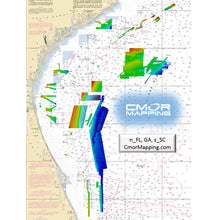
CMOR Mapping bathymetry arms you with more and better data than anybody else on the water.
NOAA Charts are included in the background.
All CMOR Cards come on Micro SD cards with a standard SD adapter included.
CMOR Compatible Devices:
Raymarine
CMOR cards are compatible with all units capable of running the Lighthouse II and Lighthouse 3 interfaces. In order to support CMOR Mapping, units must have at least v17 software installed. Units include:
- Axiom Series
- Axiom Pro
- Hydbrid Touch
- aSeries
- cSeries
- eSeries
- eS Series
- gS Series
- Dragonfly Series
CMOR Mapping Noertheast Florida, Georgia and South Carolina CMOR Card for Raymarine
Model: NEFL002R- The north FLORIDA/GEORGIA/SOUTH CAROLINA Card covers of some of the best fishing, diving, and deep dropping spots in the Atlantic Ocean.
- 100 Fathom Curve (57nm ESE of Georgetown SC)
- Charleston Bump and many surrounding areas (swordfish mecca)
- Georgetown Hole (47nm SSE Georgetown SC)
- 100 / 400 area (59nm SE Little River Inlet, SC)
- Winyah Scarp (43nm SE Georgetown SC)
- "GROUPER" ledges 120-128ft Depth (49nm East St. Simons), Plus many more
- The northern section of the original NEFL data starts due east of Fernandina Beach in an area locals call the R4 Navy Tower Bottom. Depths range from 100' to 2,200'. This section is 316 square miles and runs from the 30?45.00' N line down to the 30?36.00' N line.
- The southern section of the original NEFL data starts east of Jacksonville on the 30?29.00' N line and runs south to the 29?53.00' N line, which is due east of St. Augustine. This section covers 941 square miles of data with depths ranging from 100' to 1,200'.
- This is a must-have CMOR Card if you like to dive the secret ledges on the top of the break, bottom fish for snapper grouper on the ledge, troll for wahoo and other pelagics, deep drop for tiles and snowy grouper, or want to try daytime sword fishing in 1,500' of water.
- CMOR Mapping bathymetry arms you with more and better data than anybody else on the water.
- All CMOR Cards come on Micro SD cards with a standard SD adapter included.
CMOR cards are compatible with all units capable of running the Lighthouse II and Lighthouse 3 interfaces. In order to support CMOR Mapping, units must have at least v17 software installed. Units include: Axiom Series, Axiom Pro, Hydbrid Touch, aSeries, cSeries, eSeries, eS Series gS Series, Dragonfly Series
The best diving and bottom-fishing spots are the ones that don’t show up on the paper or digital charts and aren’t marked on commercially available fishing maps. Instead, they’re the forgotten wrecks, the isolated reefs, the ledges hidden between the contour lines — places you spend hundreds of hours on the water and burn thousands of dollars in fuel to find.
Now, though, CMOR Mapping’s chartplotter-compatible bathymetry reveals those spots for the first time. With resolution as high as 1 meter (each pixel represents a single square meter of bottom) and coverage of the entire bottom, you see every bump in remarkable detail. Just as importantly, you see the areas of featureless underwater desert, where you don’t need to spend your time looking.
Most fishing maps and charts that show depth contour lines interpolate those lines from historical sounding data. In other words, the contours are drawn by looking at the measured depth at a number of points and then making educated guesses about what the bottom looks like between those points. In many cases, the results are fairly accurate. But isolated features — a 5-foot ledge between two soundings a quarter mile apart, for example — are easily missed.
In contrast, CMOR Mapping data is the result of methodical surveys with high-resolution echosounders. There is no interpolation, no guesswork, and no unverified "hotspots" reported by local captains. All you see is a complete, accurate, and highly detailed representation of the bottom, including many features that are not shown on any other chart or fishing map.
The value of CMOR Mapping imagery when fishing or diving a new area is obvious — instead of relying on "public numbers" or feeling your way along looking for more productive spots, you’re immediately in the game.
Not only will you see features you never knew existed — things you may have run right past a hundred times — but you’ll also see known features in game-changing detail. Large, dispersed artificial reef areas, for example, come into an entirely new level of focus, with each individual piece of structure clearly visible.
"RaymarineNot Applicable "
Frequently Asked Questions (FAQ) About CMOR MAPPING NE FL, GA, SC F/ RAYMARINE
Who is the CMOR Mapping?Who is the CMOR Mapping?
Save $228 when you buy the CMOR Mapping North Florida, Georgia & South Carolina f/Raymarine for only $471 from NVN Marine! Same day shipping before 3pm.
CMOR Mapping North Florida, Georgia & South Carolina f/Raymarine Videos
CMOR Mapping North Florida, Georgia & South Carolina f/Raymarine Technical Specifications
| Type: | |
|---|---|
| Vendor: |
CMOR Mapping |
| Weight: |
0.1 lb |
| User Guide: |
CMOR Mapping North Florida, Georgia & South Carolina f/Raymarine User Reviews
CMOR Mapping North Florida, Georgia & South Carolina f/Raymarine Shipping & Return
| Shipping Weight: |
0.1 lb |
|---|---|
| Box Sizes: |
1.00 (h) x 5.00 (w) x 8.00 (l) |
| Cubic Feet: |
40.0 |
| Returnable: |
Yes |
| USPS First Class: |
Yes |
For detailed shipping policy please check our Shipping Policy and you can find our Return and Refund Policy here.