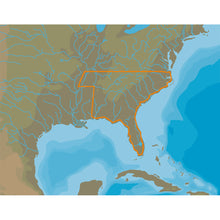
C-MAP 4D Lakes NA-D074 South East
C-MAP 4D Lakes NA-D074 South East Product Description
4D Lakes NA-D074 South East
C-MAP charts have long been held in high regard by boaters because they combine aesthetically pleasing vector electronic charts with reliable sources. When buying C-MAP boaters can be assured that the charts they are getting are of the highest standard.
C-Map 4D will provide boaters with charts packed additional features such as raster chart views or Satellite images* to maximize situational awareness.
Coverage Area:
Lakes and major rivers of the South East area of the USA in the states of: Florida, Georgia, Alabama, Tennessee, South Carolina, North Carolina.
Advanced coastal and offshore maps of the United States with detailed navigation and fishing information. The lower 48 states, Alaska, Hawaii and all areas of the Caribbean can use the same card. improve...
Frequently Asked Questions (FAQ) About C-MAP 4D Lakes NA-D074 South East
Who is the C-MAP?How to describe C-MAP 4D Lakes NA-D074 South East?
What is the card format of this product?
Who is the C-MAP?
How to describe C-MAP 4D Lakes NA-D074 South East?
What is the card format of this product?
Buy with the best price C-MAP 4D Lakes NA-D074 South East for only $187 from NVN Marine! Same day shipping before 3pm.
C-MAP 4D Lakes NA-D074 South East Technical Specifications
| Type: | |
|---|---|
| Vendor: |
C-MAP |
| Weight: |
0.2 lb |
| Card Format: |
MicroSD/SD |
C-MAP 4D Lakes NA-D074 South East User Reviews
C-MAP 4D Lakes NA-D074 South East Shipping & Return
| Shipping Weight: |
0.2 lb |
|---|---|
| Box Sizes: |
1.00 (h) x 5.00 (w) x 8.00 (l) |
| Cubic Feet: |
40.0 |
| Returnable: |
Yes |
| USPS First Class: |
Yes |
For detailed shipping policy please check our Shipping Policy and you can find our Return and Refund Policy here.


