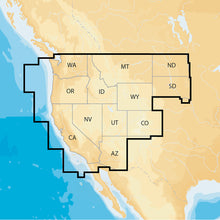
Navionics Navionics+ Regions - West - Preloaded MSD Format
It will be shipped by UPS Ground.
Navionics Navionics+ Regions - West - Preloaded MSD Format Product Description
Navionics+ Regions - West - Preloaded MSD Format
- Marine and lake charts
- One foot contours
- Daily updates and advanced features for one year
Boat safer and fish smarter. Max-detailed cartography for marine and lakes that is updated daily, makes Navionics+ the perfect choice for cruising and fishing. Get Nautical Chart, the most accurate navigational data; SonarChart™, an exclusive 1 ft HD bathymetry map; and Community Edits, local content from the community. Daily updates and advanced features are included for one year. Simply plug your card into your PC/Mac and register at navionics.com. USB reader provided.
- Preloaded with Nautical Chart and SonarChart™; Community Edits are downloadable
- Enjoy advanced features: SonarChart™ Live, Advanced Map Options and Plotter Sync.
- Enhance SonarChart™ with sonar logs you collect.
NAV+WE: West Coverage Details
- AZ, CA, CO, ID, MT, ND, NV, OR, SD, UT, WA and WY
- 2,700 lakes and growing
- Full marine coverage and Canadian waters of Puget Sound
It's safer to ride a boat, to fish smarter, and make the most of your time on the water! Navionics+ is an all-in-one maximum detailed mapping technology for oceans and lakes, and is ideal for Navionics+.
Frequently Asked Questions (FAQ) About Navionics Navionics+ Regions - West - Preloaded MSD Format
Who is the Navionics?How to describe Navionics Navionics+ Regions - West - Preloaded MSD Format?
What is the type of the product?
What is the cartography of product?
What is the connection interface of product?
What is the card type of this product?
Who is the Navionics?
How to describe Navionics Navionics+ Regions - West - Preloaded MSD Format?
What is the type of the product?
Software
- Precision and Accuracy: View the exact position of your vessel, detailed coastal features, obstructions, waterways, and depth contours so you will always know precisely where you are and where you want to go.
- Advanced Features: 3D view, high-resolution photo/chart overlay, marina photos, and more are all part of the Navionics Platinum+ package.
What is the cartography of product?
What is the connection interface of product?
What is the card type of this product?
Save $20 when you buy the Navionics Navionics+ Regions - West - Preloaded MSD Format for only $128 from NVN Marine! Same day shipping before 3pm.
Navionics Navionics+ Regions - West - Preloaded MSD Format Videos
Navionics Navionics+ Regions - West - Preloaded MSD Format Technical Specifications
| Type: | |
|---|---|
| Vendor: |
Navionics |
| Weight: |
0.3 lb |
| User Guide: | |
| Product Brochure: |
Navionics Navionics+ Regions - West - Preloaded MSD Format User Reviews
Navionics Navionics+ Regions - West - Preloaded MSD Format Shipping & Return
| Shipping Weight: |
0.3 lb |
|---|---|
| Box Sizes: |
1.00 (h) x 5.00 (w) x 7.00 (l) |
| Cubic Feet: |
35.0 |
| USPS First Class: |
Yes |
For detailed shipping policy please check our Shipping Policy and you can find our Return and Refund Policy here.


