OUT OF STOCK

C-MAP MAX NA-M033 - ATL Coast Gulf & Caribbean - SD™ Card
Free Ground Shipping (2-6 Days Delivery Time)
SKU: 30153 - MPN: NA-M033SDCARD
$339.00
$339.00
( / )
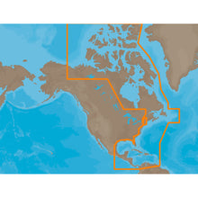
NA-M033 => Atlantic Coast, Gulf of Mexico and CaribbeanCoverage includes most of the eastern coastline of North America. Canadian coverage starts in Arctic Canada and continues east to Hudson Bay, Ungava Bay and Frobisher Bay before continuing south down the Labrador coast to Newfoundland, the Gulf of St. Lawrence and...

Same Day
Shipping (3PM)
Free Returns
Within 30 days
C-MAP MAX NA-M033 - ATL Coast Gulf & Caribbean - SD™ Card Product Description
NA-M033 => Atlantic Coast, Gulf of Mexico and CaribbeanCoverage includes most of the eastern coastline of North America. Canadian coverage starts in Arctic Canada and continues east to Hudson Bay, Ungava Bay and Frobisher Bay before continuing south down the Labrador coast to Newfoundland, the Gulf of St. Lawrence and Nova Scotia. The St. Lawrence River is covered down to Montreal. US coverage picks up at Passamaquoddy Bay and heads south down the Atlantic coast, picking up all of Chesapeake Bay, and continuing down to Key West, FL before turning into the Gulf of Mexico. The Gulf of Mexico, from Key West, FL to Brownsville, TX is covered in its entirety. Latin America is covered from the Mexico/US border over around the Yucatan Peninsula along the coasts of Belize, Honduras, Nicaragua, Costa Rica and through the Panama Canal before turning north up the Pacific coastline to Salina Cruz, Mexico. All the islands of the Caribbean are covered, from the Bahamas over to Cuba, east to the Virgin Islands and down to Grenada. The Caribbean coasts of Colombia and Venezuela are also covered, from Golfo de Uraba in Colombia over to the Rio Orinoco delta in Venezuela. Coverage of Bermuda is also included.This product may not be returned to the original point of purchase. Please contact the manufacturer directly with any issues or concerns.
Na-m033 covers most of the eastern coastline of North America along the Atlantic coast, the Gulf of Mexico and the Caribbean Sea. Reporting in Canada began in Arctic Canada and continues...
Frequently Asked Questions (FAQ) About C-MAP MAX NA-M033 - ATL Coast Gulf & Caribbean - SD™ Card
Who is the C-MAP?How to describe C-MAP MAX NA-M033 - ATL Coast Gulf & Caribbean - SD™ Card?
What is the card format of this product?
Who is the C-MAP?
C-MAP cartography products and services include multiple formats for lakes, coasts, and oceans across the globe. With detailed coverage of over 8,000 lakes in the USA alone and over 7.2 million points of interest globally, C-MAP continues to invest in improving the coverage and quality of detail shown.
How to describe C-MAP MAX NA-M033 - ATL Coast Gulf & Caribbean - SD™ Card?
Na-m033 covers most of the eastern coastline of North America along the Atlantic coast, the Gulf of Mexico and the Caribbean Sea. Reporting in Canada began in Arctic Canada and continues...
What is the card format of this product?
SD
Buy with the best price C-MAP MAX NA-M033 - ATL Coast Gulf & Caribbean - SD™ Card for only $339 from NVN Marine! Same day shipping before 3pm.
C-MAP MAX NA-M033 - ATL Coast Gulf & Caribbean - SD™ Card Technical Specifications
| Type: | |
|---|---|
| Vendor: |
C-MAP |
| Weight: |
0.1 lb |
| Card Format: |
SD |
| User Guide: |
C-MAP MAX NA-M033 - ATL Coast Gulf & Caribbean - SD™ Card User Reviews
C-MAP MAX NA-M033 - ATL Coast Gulf & Caribbean - SD™ Card Shipping & Return
| Shipping Weight: |
0.1 lb |
|---|---|
| Box Sizes: |
1.00 (h) x 6.00 (w) x 10.00 (l) |
| Cubic Feet: |
60.0 |
| USPS First Class: |
Yes |
For detailed shipping policy please check our Shipping Policy and you can find our Return and Refund Policy here.