OUT OF STOCK

C-MAP MAX NA-M026 - Great Lakes & The Maritimes - C-Card
SKU: 30127 - MPN: NA-M026C-CARD
$279.00
$279.00
( / )
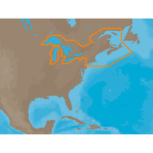
NA-M026 => Great Lakes, Northeast Coast and ApproachesCoverage of the Great Lakes, St. Lawrence River and Northeast United States. Coverage of the Great Lakes also includes Fox River and Lake Winnebago, Lake St. Clair, Rideau Canal, Ottawa River and the Trent-Severn Waterway. Includes all coastal charts for New Brunswick and...

Same Day
Shipping (3PM)
Free Returns
Within 30 days
C-MAP MAX NA-M026 - Great Lakes & The Maritimes - C-Card Product Description
NA-M026 => Great Lakes, Northeast Coast and ApproachesCoverage of the Great Lakes, St. Lawrence River and Northeast United States. Coverage of the Great Lakes also includes Fox River and Lake Winnebago, Lake St. Clair, Rideau Canal, Ottawa River and the Trent-Severn Waterway. Includes all coastal charts for New Brunswick and Nova Scotia in Canada and Maine, New Hampshire, Massachusetts, Connecticut and New York in the U.S. Also included is coverage of the Hudson River and Lake Champlain as well as the Erie Barge Canal.
This product may not be returned to the original point of purchase. Please contact the manufacturer directly with any issues or concerns.
Lawrence River and Northeast America. The coverage of the Great Lakes also includes the Fox River and Lake Winnebago, the holy lake. Clare, Knight River, Ottawa River and Trent River -...
Frequently Asked Questions (FAQ) About C-MAP MAX NA-M026 - Great Lakes & The Maritimes - C-Card
Who is the C-MAP?How to describe C-MAP MAX NA-M026 - Great Lakes & The Maritimes - C-Card?
What is the card format of this product?
Who is the C-MAP?
C-MAP cartography products and services include multiple formats for lakes, coasts, and oceans across the globe. With detailed coverage of over 8,000 lakes in the USA alone and over 7.2 million points of interest globally, C-MAP continues to invest in improving the coverage and quality of detail shown.
How to describe C-MAP MAX NA-M026 - Great Lakes & The Maritimes - C-Card?
Lawrence River and Northeast America. The coverage of the Great Lakes also includes the Fox River and Lake Winnebago, the holy lake. Clare, Knight River, Ottawa River and Trent River -...
What is the card format of this product?
C-Card
Buy with the best price C-MAP MAX NA-M026 - Great Lakes & The Maritimes - C-Card for only $279 from NVN Marine! Same day shipping before 3pm.
C-MAP MAX NA-M026 - Great Lakes & The Maritimes - C-Card Technical Specifications
| Type: | |
|---|---|
| Vendor: |
C-MAP |
| Weight: |
0.1 lb |
| Card Format: |
C-Card |
| User Guide: |
C-MAP MAX NA-M026 - Great Lakes & The Maritimes - C-Card User Reviews
C-MAP MAX NA-M026 - Great Lakes & The Maritimes - C-Card Shipping & Return
| Shipping Weight: |
0.1 lb |
|---|---|
| Box Sizes: |
1.00 (h) x 6.00 (w) x 10.00 (l) |
| Cubic Feet: |
60.0 |
| USPS First Class: |
Yes |
For detailed shipping policy please check our Shipping Policy and you can find our Return and Refund Policy here.