


Garmin 0100259401 Chart Plotter

Shipping (3PM)
Within 30 days
Garmin 0100259401 Chart Plotter Product Description
Imagine gliding across your favorite lake or coastal waterway, with crystal-clear images of the underwater world revealing every hidden structure, school of fish, and contour below. The Garmin ECHOMAP UHD2 7-inch chartplotter transforms how you navigate and fish, blending cutting-edge sonar imaging with intuitive mapping to give you an edge on the water. Whether you're a weekend angler chasing bass in shallow coves or a serious boater plotting offshore routes, this device delivers reliable performance in a compact, sunlight-readable package.
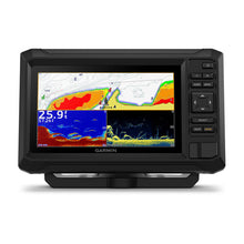
At its core, high-contrast vivid color palettes on the scanning sonar make separating fish from weeds or rocks effortless, even in murky conditions. Paired with the included GT20-TM transducer, it supports dual sonar types—traditional CHIRP for wide-area coverage and ClearVü for photo-like side and down views—ensuring no target slips away. Anglers report spotting fish arches sharper than ever, thanks to the enhanced resolution that cuts through clutter like a knife.
Unlock Crystal-Clear Sonar Views
Dive deeper into the water column with Garmin's proven CHIRP traditional sonar operating across 70/83/200 kHz frequencies. This delivers exceptional target separation, letting you distinguish individual fish in a boil from bottom-hugging structure. Complementing it is ClearVü scanning sonar at 260/455/800/1000/1200 kHz, which paints nearly photographic images of what's directly beneath and to the sides of your boat.
Real-world users love how the vivid palettes pop on the 7-inch WVGA display (800 x 480 pixels), optimized for inboard or outboard mounting. No more squinting at faded screens—the TN panel shines under direct sun, with adjustable backlight for dawn patrols or dusk bites. Pro tip: Fine-tune sensitivity mid-session to adapt to water depth or temperature shifts, maximizing detail on everything from suspended walleye to reef edges.
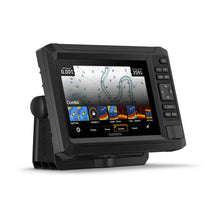
Navigate with Confidence Using Preloaded Maps
Preloaded with U.S. LakeVü g3 inland maps, this chartplotter covers thousands of lakes with 1-foot contours, underwater features, and shoreline details sharper than many competitors. Switch seamlessly to BlueChart g3 coastal charts for bays, inlets, and harbors, or tap into the worldwide basemap for global adventures. What sets it apart? Compatibility with premium Garmin Navionics+ and Navionics Vision+ cartography, including high-res bathymetry and daily updates via the app.
Custom mapping shines with Quickdraw Contours, where you log your own sonar data to build personalized HD maps on the fly. Share them wirelessly with the Garmin community, so next trip, you're fishing proven spots others overlook. For tournament pros, waypoint management is a breeze—mark hot bites, group them by species, and route around no-wake zones effortlessly.
Stay Connected On and Off the Water
Built-in Wi-Fi opens a world of convenience, pairing with the free Garmin Connect mobile app. Download software updates, access OneChart for map purchases, and pull in Quickdraw Community data from fellow users who've mapped your waters. It's like having a network of local experts at your fingertips.
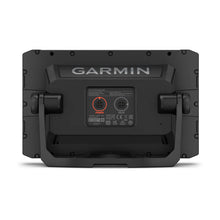
Network multiple units via Wi-Fi to share sonar screenshots, waypoints, and routes in real-time—perfect for multi-boat fishing parties. For advanced setups, NMEA 2000 compatibility integrates with engine data, autopilots, and radar, creating a unified helm display without cables everywhere.
Rugged Build for Real-World Demands
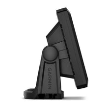
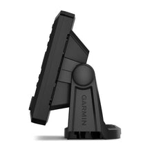
Measuring just 9.1 x 5.6 x 2.6 inches, this keyed interface unit fits tight consoles yet feels premium. The IPX7 waterproof rating shrugs off splashes, rain, or the occasional rogue wave. Simple keypad controls keep gloves-on operation intuitive—no touchscreen smudges or freezes in wet hands.
Durability meets everyday ease: Quick-release bracket for theft-proof storage, plus flush or surface mounting options. Saltwater anglers appreciate the corrosion-resistant materials, while freshwater folks value the vibration-proof design for rough trails to remote lakes.
Streamlined Setup and Everyday Tips
Getting started is straightforward—transom-mount the GT20-TM transducer parallel to the hull bottom for optimal readings, route cables cleanly through existing gimbal holes, and power up via 12V DC. Calibrate sonar in open water, then sync maps over Wi-Fi before launch.
For peak performance, clean the transducer face regularly to avoid signal loss from algae buildup. Update firmware seasonally to unlock new features like improved noise rejection. Troubleshoot faint sonar? Check keel clearance and adjust gain—common fixes that keep you fishing longer.
Why Anglers and Boaters Swear By It
This chartplotter isn't just gear; it's a game-changer for dialing in patterns. Bass fishermen track staging fish on ClearVü edges, walleye hunters grid-search with CHIRP spreads, and offshore captains plot safe passages with layered charts. Its blend of affordability, sonar punch, and expandability outshines bulkier systems, earning top marks for value in user reviews.
Backed by Garmin's marine expertise, it evolves with you—from casual outings to competitive pursuits—delivering returns on every outing through bigger catches and safer navigation.
Frequently Asked Questions
What sonar frequencies does the Garmin ECHOMAP UHD2 7-inch support?
It features built-in CHIRP traditional sonar at 70/83/200 kHz and ClearVü scanning sonar at 260/455/800/1000/1200 kHz for versatile coverage.
Does it come with preloaded maps, and what types?
Yes, preloaded with U.S. LakeVü g3 inland maps, BlueChart g3 coastal charts, and a worldwide basemap, plus support for Garmin Navionics+ upgrades.
Is the display sunlight-readable?
Absolutely—the 7-inch WVGA TN panel with 800 x 480 resolution and adjustable backlight performs brilliantly in direct sunlight.
How does Wi-Fi connectivity benefit users?
Wi-Fi enables app pairing for software updates, OneChart access, Quickdraw Community data sharing, and wireless networking with other compatible units.
What transducer is included, and what does it offer?
The GT20-TM transducer provides Garmin traditional CHIRP and ClearVü scanning sonars with vivid color palettes for superior target identification.
Is it suitable for saltwater use?
Yes, with IPX7 waterproofing and corrosion-resistant construction, it's built tough for both freshwater lakes and coastal saltwater environments.
Can I create custom maps?
Quickdraw Contours lets you record sonar data to generate your own high-definition maps, shareable with the Garmin community.
High-contrast vivid scanning sonar color palettes make it easier than ever to distinguish targets and structure. Your ECHOMAP UHD2 device supports a variety of Garmin transducers for two types of sonar: Garmin traditional and ClearVü scanning sonars. Know the waters you’re in as if you grew up fishing them by using built-in LakeVü g3 inland maps, BlueChart g3 coastal charts or worldwide basemap with support for Garmin Navionics+ ™ and Garmin Navionics Vision+ ™ marine cartography. Built-in Wi-Fi connectivity pairs with the free all-in-one mobile app for access to the OneChart ™ feature, software updates, Garmin Quickdraw ™ Community data and more2.
Garmin 0100259401 Attributes
- Maps: U.S. Lakevü G3 Map
- Display Size: 7 Inch LCD
- Display Type: WVGA, TN With 800 x 480 Pixels Resolution
- Interface: Keypad
- Dimensions: 9.1 Inch Length X 5.6 Inch Width X 2.6 Inch Height
- Waterproof: IPX7 Rating Waterproof
- Sonar Compatibility: Clearvü Built-in 260/455/800/1000/1200 kHz And Traditional Built-in Chirp 70/83/200 kHz Sonar
Garmin 0100259401 Features & Benefits
- Built-In Wi-Fi ® Connectivity With Compatible Garmin Chartplotters To Wirelessly Share Sonar, Waypoints, And Routes
- Features GT20-TM Transducer For Garmin Traditional And ClearVü Scanning Sonars With Vivid Color Palettes
- Easy-To-Use Keyed 5 Inch Chartplotter With A Bright, Sunlight-Readable Screen
- Bright 7 Inch Keyed Display Is Made For Convenience
- Get Double The Views1 With Garmin CHIRP Traditional And ClearVü Scanning Sonars
- With Crisp, Clear Traditional Sonar And Brilliant ClearVü Sonar, The Fish Will Have Nowhere To Hide
- High-Contrast Vivid Scanning Sonar Color Palettes Make It Easier Than Ever To Distinguish Targets And Structure
- Limited 1 Year Warranty
Garmin 0100259401 Installation Instructions
Garmin 0100259401 Warranties
Garmin 0100259401 Technical Bulletins
Frequently Asked Questions (FAQ) About Garmin 0100259401 Chart Plotter
Who is the Garmin?Is this product waterproof?
What is the display type of the product?
What is the display size of the product?
What is the controlling interface of the product?
What is the dimensions of the product?
Who is the Garmin?
Is this product waterproof?
What is the display type of the product?
What is the display size of the product?
What is the controlling interface of the product?
What is the dimensions of the product?
Save $252 when you buy the Garmin 0100259401 Chart Plotter for only $347 from NVN Marine! Same day shipping before 3pm.
Garmin 0100259401 Chart Plotter Videos
Garmin 0100259401 Chart Plotter Technical Specifications
| Type: | |
|---|---|
| Vendor: |
Garmin |
| Weight: |
5.0 lb |
Garmin 0100259401 Chart Plotter User Reviews
Garmin 0100259401 Chart Plotter Shipping & Return
| Shipping Weight: |
5.0 lb |
|---|---|
| Box Sizes: |
6.60 (h) x 8.20 (w) x 11.40 (l) |
| Cubic Feet: |
616.968 |
For detailed shipping policy please check our Shipping Policy and you can find our Return and Refund Policy here.