OUT OF STOCK
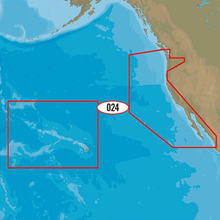
Max, U.S. W. Coast & Hawaii
Free Ground Shipping (2-6 Days Delivery Time)
SKU: 2001186 - UPC: 9420024185131 - MPN: M-NA-M024-MS
$291.00
$291.00
( / )
C-MAP MAX Cartography on SD Card With C-MAP MAX, you'll enjoy exclusive features combined with continually updated navigation data.CMAP MNAM024MS Attributes CMAP MNAM024MS Features & Benefits Dynamic NavAids and Dynamic tides and currents predict the time, level, direction and strength of currents and tides. Guardian Alarm performs an automatic forward-scanning...
Max, U.S. W. Coast & Hawaii Product Description
C-MAP MAX Cartography on SD Card With C-MAP MAX, you'll enjoy exclusive features combined with continually updated navigation data.
CMAP MNAM024MS Attributes
CMAP MNAM024MS Features & Benefits
- Dynamic NavAids and Dynamic tides and currents predict the time, level, direction and strength of currents and tides.
- Guardian Alarm performs an automatic forward-scanning check for obstacles. Use this feature as an added backup to alert you if you head toward a potentially harmful object.
- Photos and diagrams in high-definition of ports, marinas and significant navigational marks will help you to familiarize yourself with new destinations and passages.
- Route-check is an extension of Guardian Alarm, helping keep you safe by indicating obstacles along the segments between waypoints.
- Depths and land elevation show the usual depth information and the colors make it easy to distinguish different water depths and land elevations.
- Detailed harbor charts so docking in unfamiliar ports is no problem, for precise layouts of thousands of marinas, including slip spaces, restricted areas and other valuable navigation information.
- Perspective view gives a bird's-eye view of your navigation area, it tilts the chart view to a 45-degree angle.
- C-Marina Port Database has details on more marinas than other charts on the market. Displays harbor hours, harbor master contact info, nearby lodging and restaurants, VHF call-in details and more
- Points of interest (POIs) and road mapping helps whether you're looking for a restaurant or museum, you can find it in our extensive database of local services and cultural highlights.
- Multi-language capability -- All C-MAP charts can be displayed in both English and the local language of each region. More than 140 languages are available.
Max Wide Chart on SD/Micro-SD Card, MFG# M-NA-M024-MS, US West Coast & Hawaii. Vector charts with dynamic nav-aids, tides & currents, Guardian Alarm, port photos and detailed info, route check, depths, land elev., perspective view, and points of interest.
Frequently Asked Questions (FAQ) About C-MAP Max, U.S. W. Coast & Hawaii
Who is the C-MAP?How to describe C-MAP Max, U.S. W. Coast & Hawaii?
Who is the C-MAP?
C-MAP cartography products and services include multiple formats for lakes, coasts, and oceans across the globe. With detailed coverage of over 8,000 lakes in the USA alone and over 7.2 million points of interest globally, C-MAP continues to invest in improving the coverage and quality of detail shown.
How to describe C-MAP Max, U.S. W. Coast & Hawaii?
"
"
C-MAP NA-M024 Max Wide microSD
Model: M-NA-M024-MS- Updated twice annually to provide all the latest detail and information
- Compatible with dozens of chartplotters from top manufacturers
- Extensive coverage of coastal waters, lakes and rivers
C-MAP MAX electronic charts have been a worldwide standard for years, providing cruisers, sailors and fishermen with the accurate, up-to-date chart data they need to enjoy each day on the water. Still a leading choice of navigators and chartplotter manufacturers around the globe.
Specifications| Dynamic NavAids | Yes |
| Dynamic tides | Yes |
| Gaurdian alarm | Yes |
| Detailed marina port plans | Yes |
| Photos and diagrams | Yes |
| Route-check | Yes |
| Depths and land elevation | Yes |
| Detailed harbor | Yes |
| Perspective view | Yes |
| C-Marina Port Database | Yes |
| Points of interest | Yes |
| Multi-language capability | Yes |
Buy with the best price Max, U.S. W. Coast & Hawaii for only $291 from NVN Marine! Same day free shipping before 3pm.
Max, U.S. W. Coast & Hawaii Technical Specifications
| Type: | |
|---|---|
| Vendor: |
C-MAP |
| Weight: |
0.2 lb |
Max, U.S. W. Coast & Hawaii User Reviews
Max, U.S. W. Coast & Hawaii Shipping & Return
| Shipping Weight: |
0.2 lb |
|---|---|
| Box Sizes: |
0.00 (h) x 5.00 (w) x 7.00 (l) |
| Cubic Feet: |
0.0 |
| Returnable: |
Yes |
| USPS First Class: |
Yes |
For detailed shipping policy please check our Shipping Policy and you can find our Return and Refund Policy here.


