
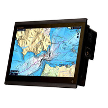
Furuno TZT-16X 16 TZtouchXL Multifunction Display
Free Ground Shipping (2-6 Days Delivery Time)

Shipping (3PM)
Within 30 days
Furuno TZT-16X 16 TZtouchXL Multifunction Display Product Description
Discover Unmatched Clarity and Control on the Water
Imagine commanding your vessel with a helm display that feels like an extension of your instincts. The Furuno TZtouchXL series, particularly the 16-inch model, transforms navigation into a seamless experience. Its all-glass IPS panel delivers vivid Full HD visuals from every angle, ensuring you spot critical details even in rough seas or under direct sunlight. Mariners and anglers alike rave about how this multifunction display blends cutting-edge tech with everyday reliability, making long days on the water less about fighting gear and more about enjoying the journey.
What sets it apart? A powerhouse hexacore processor responds instantly to touches and swipes, mimicking the fluidity of your smartphone. Edge-swipe menus keep essential tools at your fingertips, while hybrid control options add tactile precision for those gloves-on moments. Whether you're plotting a coastal cruise or chasing deep-water trophies, this display networks effortlessly with Furuno's ecosystem, scaling from solo setups to multi-station bridges.
Stay Safe with Advanced Radar Intelligence
Furuno's radar integration shines here, pairing with magnetron or solid-state NXT domes for unparalleled target discrimination. Target Analyzer™ flags threats in color, while Fast Target Tracking locks on vectors in seconds. Bird Mode reveals bait balls from afar, and Rain Mode cuts through storms to highlight vessels.
New gems like Risk Visualizer™ paint a 360-degree collision risk map with dynamic icons, going beyond basic CPA/TCPA alerts. Pair it with AI Avoidance Route™ on TZ MAPS, and it auto-suggests detours around clusters of traffic—peace of mind for busy waterways.
"In crowded inlets, Risk Visualizer has eyes where I don't, preventing close calls before they happen."
Dominate the Depths: Built-in CHIRP Fish Finder and Side-Scan
Anglers, this is your edge. Dual-channel 1kW TruEcho CHIRP™ sweeps wide frequencies (40-240kHz) for crystal-clear separation of species and structure. ACCU-FISH™ estimates size on-screen, while Bottom Discrimination reveals gravel, sand, or rock compositions.
Built-in CHIRP Side-Scan at 230kHz or 455kHz paints high-def portraits up to 750 feet per side, exposing wrecks, reefs, and lurking schools without turning the boat. Network it across displays for shared intel on bigger vessels.
- Triple-beam modes track fish direction: port, starboard, or straight down.
- 3D history scans build intuitive seabed models for hotspot selection.
- Scalable power for deep-drop pros with add-on modules like DFF3D Multibeam Sonar.
Fishermen share stories of landing limits by pinpointing structure others miss, proving this isn't hobby-grade—it's tournament-ready.
Seamless Networking and Intuitive Controls
One LAN port networks unlimited TZtouchXL units, sharing radar, sonar, and GPS data fleet-wide. NMEA2000/0183, HDMI video, and USB streamline peripherals like cameras, autopilots, and AIS. Wireless LAN enables cloud backups of marks, routes, and logs—retrieve from anywhere with a free account.
Touch-first UI with optional RotoKey™ knobs for hybrid mastery. Customize screens: split radar/fishfinder/chart, or go full immersive. IP56 waterproofing and -15°C to +55°C resilience handle salt spray and extremes.
Why Mariners Choose TZtouchXL for Every Mission
For coastal cruisers, it's effortless route planning and traffic avoidance. Offshore adventurers get deep-water sonar and reliable comms. Charter captains outfit multi-helms without complexity. The 16-inch strikes the sweet spot: large enough for clarity, compact for flybridges.
Users highlight the processor's speed—no lag during zooms or overlays—and the IPS viewing cone, visible to crew from all seats. Backed by Furuno's marine legacy, it delivers uptime when it counts.
Frequently Asked Questions
What screen specifications does the Furuno TZT-16X offer?
It features a 15.6-inch wide color TFT multi-touch IPS LCD with Full HD 1920x1080 resolution and 900 cd/m² brightness for superior visibility in all conditions.
Does the TZT-16X have a built-in fish finder?
Yes, it includes a dual-channel 1kW TruEcho CHIRP™ fish finder supporting CW 50/200kHz and CHIRP 40-240kHz bands, with features like ACCU-FISH™ and bottom discrimination.
What side-scan capabilities are available?
Built-in CHIRP Side-Scan at 230kHz or 455kHz covers up to 750 feet per side, displaying structure and fish in full, half, quarter, or sixth screen modes.
Which charts does it support?
TZ MAPS for advanced bathymetric and customizable charts, plus MM3 Vector and CMOR (U.S. only), with editable layers and AI routing.
How does it integrate with radar?
Compatible with Furuno X-Class magnetron and NXT solid-state radars, offering Target Analyzer™, Risk Visualizer™, Bird Mode, and up to 100 ARPA targets.
What are the environmental ratings?
IP56 waterproofing, operating from -15°C to +55°C, and up to 93% humidity at +40°C, built for harsh marine environments.
Can it network with other displays?
Yes, via Gigabit Ethernet LAN, supporting unlimited TZtouchXL units for shared radar, sonar, and data across the network.
Furuno TZT16X NavNet TZtouch3 Chart Plotter, 16"" All-Glass IPS Display FULL HD (1920x1080)
Model: TZT16X- New TZ MAPS for highly-detailed navigation and fishing charts
- Built-in Dual Channel 1kW TruEcho CHIRP™ & CW Fish Finder
- Built-in 230kHz or 455kHz CHIRP Side-Scan
- Powerful hexacore processor for rapid response
Explore the future of navigation with NavNet TZtouchXL - extra-large, wide 16"", 22"", and 24"" all-glass Multi Function Displays with exceptional clarity from all angles that enhance the functionality and style of your helm. Or go with the hybrid controls of the 10"" & 13"" options that make navigating intuitive and easy under any sea conditions, no matter the size of your vessel. NavNet TZtouchXL delivers the ability to tailor the helm to meet the captain's exact needs, with magnetron or Solid-State Doppler Radars, high-powered Fish Finders, AIS, Autopilot, and Deep Water Multibeam Sonar options, and more!
NavNet TZtouchXL delivers new features like TZ MAPS with BathyVision, the most advanced and capable electronic charts in the world. The TZ Maps engine draws upon a worldwide database of high-resolution information to create crisp, clear navigation with a variety of color themes and fishing charts with fully editable color palettes. TZ Maps deliver a timeless navigation experience at any magnification. It sounds incredible, and it is - you have to see it to believe it!
You asked for the simplest interface possible, and we were listening. We’ve delivered the most intuitive UI available, bar-none, and you’ll be navigating with all the power and simplicity you demand. If you swipe your phone, you can operate TZtouchXL. With edge-swipe features and single-tap menu options, you’re never more than a tap or swipe away from what you want to see or do, because NavNet TZouchXL provides the easiest and most powerful MFD on the planet.
With TZ MAPS, navigators control what map data they want to download, such as incredibly wide chart areas, satellite photos, and bathymetric data. Purchase incredibly wide chart areas directly from the MFD! Custom depth color shading and bathymetric data overlays create navigational charts of unmatched detail and clarity, rendered with a variety of color themes to provide an electronic charting experience that goes far beyond any premium chart service before it. You can create your own custom objects or make updates to charted objects, such as buoys, so when they move from their previously charted positions, they can be updated on the system on the fly. Custom user objects can be shared with other registered TZ MAPS users through TimeZero's new moderated service, and can be turned on and off in the Layers menu, available with a single edge swipe up from the bottom of the display. Purchase of any TZ MAPS area also unlocks added functionality, such as powerful AI Routing that intelligently plans out routes, taking into consideration the boat's draft as well as charted depths and navigational obstacles. The purchase of any TZ MAPS chart unlocks those charts in the free TZ iBoat app for mobile devices such as a phone or tablet, providing you with a free home planning app that will transfer your points and routes directly to the TZtouchXL. With a free TimeZero account, waypoints and routes can be easily backed up or retrieved from the cloud with just a few taps, ensuring all the data you’ve worked so hard to create remains safe and secure.
BathyVision for TZ MAPS provides truly ‘off the charts’ bathymetric data with contour lines that can be configured with a single tap. When we say configurable, we’re talking down to a resolution of a mere 3 inches between contours - that's 3x better than any other bathymetric chart currently on the market. Bathymetric data is rendered from the same high-resolution database used for TZ MAPS’ custom depth shading and can be overlaid onto the navigation charts to create fishing charts unlike any seen before.
However you spend your time on the water, you need a Radar you can rely on to keep you safe. Whether you choose the time-tested X-Class magnetron option or NXT Solid-State Doppler models, Furuno Radar delivers power and clarity like you’ve never seen and provides the assurance that you’re navigating with the most reliable and feature-packed equipment on the planet. From the compact DRS2DNXT/DRS4DNXT domes to the high-power 200-watt DRS25ANXT open array, you’ll quickly become accustomed to the dynamic features that only Furuno provides, like Target Analyzer™ that alerts you to potentially hazardous targets, Fast Target Tracking that displays a speed and course vector in seconds, best-in-the-business Bird Mode to track elusive flocks and even individual birds feeding on baitfish, and Rain Mode that can pick out and display in different colors the targets you need to see through even the nastiest of squalls. Plus, TZtouchXL introduces new Radar features, like Risk Visualizer™ and AI Avoidance Route™, that help keep you safe on the water.
Risk Visualizer™ is a unique function of Furuno Radars that provides a visual representation of potential collision risks of approaching objects around the vessel. Unlike CPA/TCPA alarms which indicate only the risks visible on the ship’s current course, Risk Visualizer™ assesses all objects 360° around the vessel. Dynamic icons are automatically created for targets with the highest collision probability, ensuring the captain has the information needed to maintain safe distances when passing.
The new AI Avoidance Route™ feature available with TZ MAPS takes all the information provided by the Radar and instantly determines and provides a safe route around those hazards.
Create your routes at home using TZ Navigator, a web browser*, or the TZ iBoat iOS App, then download them to your TZtouchXL MFD from the cloud. You can also backup all of the events on your MFD and retrieve them at home, because your data is synchronized automatically & securely. TZ Cloud saves all of your marks, routes, boundaries, photos, and catch data - with a free TimeZero account, all of your data can be backed up or retrieved with just a few taps. The purchase of any TZ MAPS chart directly from the MFD also unlocks those charts in the free TZ iBoat app for mobile devices such as a phone or tablet and TZ Pro navigation software, providing the only home planning solution you'll ever need.
Furuno’s CHIRP Side-Scan for NavNet TZtouchXL scans both port and starboard, illuminating the shape of bottom structure in high definition. CHIRP Side-Scan reveals the shape of fish targets and fish-hoarding structure to each side of your vessel. CHIRP from 230kHz or 445kHz center frequencies with thru-hull, paired, or transom mount transducer options. CHIRP Side-Scan is built into the TZT10X/13X/16X, and can be accessed by any TZtouchXL MFD on the network.
We've raised the bar for sportfishing enthusiasts once again with an MFD series designed to cater to the needs of avid anglers. The NavNet TZtouchXL series includes all the features fishermen desire, including exclusive, never-before-seen features in recreational navigation devices. The TZT10X, TZT13X, and TZT16X feature a built-in 1kW TruEcho™ CHIRP or CW Fish Finder as well as built-in 230kHz or 455kHz CHIRP Side-Scan to show fish and fish-hoarding structure in great detail port to starboard, providing crucial insights for successful fishing trips. The TZT22X and TZT24X have full control across the NavNet network, and you can tailor the system with a wide array of high-powered Fish Finders for deep dropping.
Normal down-sounding Fish Finders have a beam angle of 40 degrees or less. But with the DFF3D Multibeam Sonar, you'll see a 120-degree swath, offering seafloor coverage up to 3X water depth. Plus, with the power of the DFF3D, you can see fish directly below the boat 300m (nearly 1,000ft). The DFF3D's versatile operating modes give you a better understanding of fish targets than any normal Fish Finder can deliver. The 3D sounder history provides an intuitive and easy-to-understand 3D image of the seafloor, along with fish school icons - useful when selecting a fishing hot spot or assessing the seabed condition. Triple-Beam mode tells you not only the depth but also the direction (port/down/starboard) of fish targets. Cross Section display the real-time sea column echo in a 120 degree swath, and Side-Scan displays the shape and structure of targets both port and starboard.
Looking for an added element of control? The vertically-oriented MCU006 and horizontal MCU006H are capable of controlling any TZtouchXL MFD in the network. Both feature a comfortable RotoKey™ and ten dedicated dual-purpose buttons that operate different functions, including the ability to access the Edge Swiping functionality that makes the NavNet TZtouch series so easy to use.
Specifications| Display Unit | |
| Type | Color TFT multi touch IPS LCD |
| Screen Size | 15.6"" Wide |
| Screen Resolution | FHD 1920 x 1080 |
| Screen Brightness | 900 cd/m2 (typical) |
| Display Colors | 16,770,000 colors (Chart Plotter), 64 colors (Radar/Fish Finder) |
| GPS/WAAS | |
| Receiver Type GPS: | 72 channels, SBAS: 1 channel (C/A mode, WAAS) |
| Receiving Frequency | L1 (1575.42 MHz) |
| Time to First Fix | 100 s (cold start) |
| Accuracy | 10 m (GPS), 7 m (MSAS), 3 m (WAAS) |
| Position Update Interval | 100 ms or 10 Hz |
| CHART PLOTTER | |
| Cartography | TZ MAPS, MM3 Vector, and CMOR capable (U.S. only) |
| Memory Capacity | 30,000 user points, 100,000 points for ship's tracks, 200 planned routes (500 points per route) |
| Alarms | Anchor Watch, XTE, Depth*, Speed, Sea Surface Temperature*, Trip Distance, Fuel Gauge* (*external data required) |
| RADAR | |
| Display Modes | Head-up, North-up* *Heading input required. |
| Echo Trails | Interval: 15 s, 30 s, 1 min, 3 mins, 6 mins, 15 mins, 30 mins and continuous (Heading input required) |
| Target Tracking | 100 ARPA Targets (Radar dependent) with fully automatic target acquisition (Heading input required) |
| Radar Alarms | Guard Zone, CPA/TCPA, Video, Azimuth, Heading Line |
| FISH FINDER | |
| Transmit Frequency* | CW: 50/200 kHz, CHIRP: 40 kHz to 240 kHz (Low, Medium, and High) |
| Transducer | 300/600 W or 1 kW* *Matching box MB1100 required for some transducers. |
| Display Range | 2 to 1,200 m; shift 0 to 1,200 m (1,200-2,400m / 4,000-8,000ft) |
| Extension Mode | ACCU-FISH™, A-Scope, Auto (Fishing/Cruising), Bottom Discrimination, TruEcho CHIRP™ (with compatible transducer) |
| Picture Advance | 8 steps: x4, x2, x1, 1/2, 1/4, 1/8, 1/16, stop |
| Fish Finder Alarms | Fish School, Fish School for bottom lock |
| SIDE-SCAN | |
| Transmit Frequency* | CHIRP: 220-240KHz/445-465KHz |
| Transducer | 230kHz: 225T-PR904, 225T-SS904. 225T-TM904 / 455kHz: 455T-PR903, 455T-SS903. 455T-TM903 |
| Display Range | 750 feet to each side |
| Display Colors | Green, Blue, Amber, White |
| Display Screen Sizes | Full Screen, 1/2 Screen, 1/4 Screen, 1/6 Screen |
| Direct Connect to MFD | Direct connect to TZ10X, TZT13X, TZT16X only; may be networked with TZT22X/TZT24X |
| INTERFACE | |
| NMEA2000 | 1 Port |
| NMEA0183 | 1 Serial Output Port |
| LAN | 1 Port (1000 BASE-T) |
| USB | 1 Port (USB 3.0) for touch monitor and control unit: 1 Port USB touch output for HDMI device |
| Video I/O | Input: 1 port (NTSC/PAL) and 1 port HDMI 1920 x 1080p or less (progressive only) Output: 1 port (HDMI 1080p) |
| AUX I/O | 2 Ports (Event Switch, Buzzer Output, [10"", 13"" and 16"" KP I/O], and External Power Switch) |
| SD Card Slot | 1 Slot (Micro SDXC, rear) |
| Wireless LAN | IEEE802.11b/g/n, Transmit frequency: 2.412 to 2,462 GHz, 11dBm max |
| Transducer Connection | 1 Port 12 pin for CHIRP/CW, 1 Port 12 pin for Side-Scan |
| ENVIRONMENT | |
| Temperature | -15°C to +55° C |
| Relative Humidity | 93% or less at +40° C |
| Waterproofing | IP56 |
| POWER | |
| Voltage | 12-24 VDC |
| * Feature works only with certain transducers. Check to ensure your transducer is compatible. | |
| ** In some instances, fish size indicated on the TZtouchXL may differ from its actual size. Please carefully read the operator’s manual before utilizing this feature | |
Buy with the best price Furuno TZT-16X 16 TZtouchXL Multifunction Display for only $6195 from NVN Marine! Same day free shipping before 3pm.
Furuno TZT-16X 16 TZtouchXL Multifunction Display Technical Specifications
| Type: | |
|---|---|
| Vendor: |
Furuno |
| Weight: |
17.0 lb |
Furuno TZT-16X 16 TZtouchXL Multifunction Display User Reviews
Furuno TZT-16X 16 TZtouchXL Multifunction Display Shipping & Return
| Shipping Weight: |
17.0 lb |
|---|---|
| Box Sizes: |
1.00 (h) x 1.00 (w) x 1.00 (l) |
| Cubic Feet: |
1.0 |
| Returnable: |
Yes |
| USPS First Class: |
Yes |
| P65: |
Yes |
For detailed shipping policy please check our Shipping Policy and you can find our Return and Refund Policy here.