
Garmin ECHOMAP Ultra 2 126sv US and Coastal Canada GN+ No Transducer
Free Ground Shipping (2-6 Days Delivery Time)

Shipping (3PM)
Within 30 days
Garmin ECHOMAP Ultra 2 126sv US and Coastal Canada GN+ No Transducer Product Description
Garmin ECHOMAP Ultra 2 126sv 12-Inch Marine GPS Chartplotter with Garmin Navionics+ Mapping
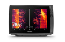
Experience unparalleled marine navigation precision with the Garmin ECHOMAP Ultra 2 126sv chartplotter, featuring a brilliant 12-inch sunlight-readable touchscreen and advanced LiveScope sonar compatibility. This professional-grade marine GPS system delivers crystal-clear underwater imaging, comprehensive coastal and inland mapping, and wireless networking capabilities that transform your fishing and navigation experience.
Revolutionary LiveScope Sonar Technology
The ECHOMAP Ultra 2 126sv supports the complete lineup of Garmin's award-winning LiveScope live-scanning sonar technology, providing real-time underwater imaging that shows fish swimming, structure details, and bottom composition with unprecedented clarity. When paired with compatible LiveScope transducers (sold separately), anglers can observe fish behavior in real-time, dramatically improving fishing success rates.
Superior Display and User Interface
- 12.1-inch WXGA IPS display with 1280 x 800 pixel resolution
- Sunlight-readable touchscreen with keyed assist for reliable operation in all lighting conditions
- IPX7 waterproof rating ensuring reliable performance in marine environments
- Bail or flush mounting options for versatile installation configurations
Advanced Sonar Capabilities
Equipped with 600-watt sonar power output, the 126sv delivers exceptional underwater imaging through multiple sonar technologies:
- Single Channel CHIRP Traditional Sonar (70/83/200 kHz) with L, M, H CHIRP frequencies
- Built-in ClearVü scanning sonar (260/455/800/1000/1200 kHz) for photo-like images beneath your boat
- Built-in SideVü scanning sonar (260/455/800/1000/1200 kHz) revealing structure and fish to the sides
- High-contrast vivid color palettes for enhanced target distinction and structure identification
Comprehensive Garmin Navionics+ Mapping
Navigate with confidence using the included Garmin Navionics+ U.S. Inland & Coastal mapping, featuring:
- Daily map updates ensuring the most current navigational information
- Auto Guidance+ technology for intelligent route planning and suggested pathways
- Depth range shading for enhanced underwater topography visualization
- Tide tables and current information for optimal fishing and navigation timing
- Support for premium Garmin Navionics Vision+ mapping (sold separately) with satellite imagery and high-resolution relief shading
Multi-Band GPS Precision
The advanced multi-band, multi-constellation GPS receiver provides superior position accuracy by utilizing GPS, GLONASS, Galileo, and BeiDou satellite systems with 10 Hz update rates. This technology delivers exceptional performance under bridges, along bluffs, and in tree-covered coves where traditional GPS systems may struggle.
Wireless Networking and Connectivity
- Wireless sharing capabilities between compatible ECHOMAP Ultra 2 and ECHOMAP UHD2 units
- Share sonar data, waypoints, and routes across your boat's network without additional cables
- ActiveCaptain app compatibility for screen recording and social media sharing of fish catches
- ANT+ wireless technology for seamless integration with compatible marine accessories
- Garmin Wi-Fi network for local wireless connections and data sharing
Professional Data Management
- 5,000 waypoint capacity for marking productive fishing spots and navigation points
- 50,000 track points with 50 saved tracks for detailed route history
- 100 navigation routes for comprehensive trip planning
- Dual microSD card slots for expanded storage and map updates
- Garmin Quickdraw Contours for creating personalized depth maps
NMEA Network Integration
Seamlessly integrate with your boat's electronics through comprehensive connectivity options:
- NMEA 2000 compatibility for modern marine network integration
- NMEA 0183 support for legacy equipment compatibility
- 2 Garmin Marine Network ports (large connector) for chartplotter networking
- 12-pin scanning sonar transducer port for advanced sonar capabilities
Technical Specifications
| Feature | Specification |
|---|---|
| Display Size | 12.1-inch diagonal (10.3" x 6.4") |
| Display Resolution | 1280 x 800 pixels WXGA IPS |
| Dimensions | 13.4" x 9.0" x 3.9" (34.1 x 22.9 x 9.8 cm) |
| Weight | 5.5 lbs (2.5 kg) |
| Power Input | 9-18 VDC |
| Current Draw | 2.5A typical / 5.0A maximum at 12V |
| Waterproof Rating | IPX7 |
| GPS Receiver | Multi-band, multi-constellation, 10 Hz |
Complete Package Contents
- ECHOMAP Ultra 2 126sv chartplotter with built-in Garmin Navionics+ mapping
- Power/data cable for 12V DC installation
- Bail mount with quick release cradle for easy removal
- Protective sun cover for display protection
- 8-pin to 12-pin transducer adapter cable
- Complete mounting hardware and installation documentation
Professional Installation Considerations
The ECHOMAP Ultra 2 126sv requires 12V DC power supply (9-18V range) with a dedicated 5-amp circuit breaker for optimal performance. The unit's compact dimensions and versatile mounting options accommodate most marine installations, while the included quick-release bail mount allows for easy chartplotter removal when leaving the boat unattended.
Why Choose the Garmin ECHOMAP Ultra 2 126sv
This advanced marine chartplotter represents the perfect balance of professional-grade fishing technology and user-friendly navigation features. The combination of LiveScope sonar support, comprehensive Navionics+ mapping, wireless networking capabilities, and multi-band GPS precision makes the 126sv an essential tool for serious anglers and recreational boaters who demand the highest level of marine electronics performance.
Frequently Asked Questions
What transducers are compatible with the ECHOMAP Ultra 2 126sv?
The 126sv is compatible with all Garmin scanning sonar transducers including the GT56UHD-TM for ClearVü and SideVü, plus all LiveScope transducers (LVS32, LVS34, LVS64) for live-scanning sonar capabilities. Transducers are sold separately.
Can I share sonar data between multiple ECHOMAP Ultra 2 units?
Yes, you can wirelessly share sonar data, waypoints, and routes between compatible ECHOMAP Ultra 2 and ECHOMAP UHD2 chartplotters. However, LiveScope sonar cannot be shared wirelessly and requires direct connection to each unit.
What mapping options are available for this chartplotter?
The unit includes Garmin Navionics+ U.S. Inland & Coastal mapping with daily updates. It also supports BlueChart G3, BlueChart G3 Vision, LakeVü G3, LakeVü G3 Ultra, Garmin Navionics Vision+, and TOPO 100K maps (sold separately).
Does the 126sv support WAAS for improved GPS accuracy?
Yes, the ECHOMAP Ultra 2 126sv supports WAAS (Wide Area Augmentation System) along with multi-band, multi-constellation GPS for enhanced position accuracy, especially beneficial in challenging environments with overhead obstructions.
What is the difference between the 126sv and other ECHOMAP Ultra 2 models?
The 126sv features a 12-inch display and includes built-in scanning sonar capabilities (ClearVü and SideVü). Other models may have different screen sizes or sonar configurations. The "sv" designation indicates scanning sonar capability.
Can I use this chartplotter for both saltwater and freshwater applications?
Absolutely. The ECHOMAP Ultra 2 126sv is designed for both saltwater and freshwater use, with IPX7 waterproof rating and included Garmin Navionics+ mapping covering both coastal and inland waters throughout the United States and coastal Canada.
Garmin ECHOMAP™ Ultra 2 126sv 12"" Chartplotters without Transducer; Includes Garmin Navionics+™ U.S. Inland & Coastal Mapping
Model: 010-02882-00- SUPPORTS LIVESCOPE™ SONAR1 AND MORE
- WIRELESSLY NETWORK; SHARE SONAR, WAYPOINTS AND ROUTES2
- CAPTURE SCREEN RECORDINGS TO SHARE FISH CATCHES
- MULTI-BAND GPS FOR IMPROVED POSITION ACCURACY
With big, crisp, sunlight-readable touchscreen displays, these versatile chartplotters put a world of fishfinding capability at your fingertips. They’re available with built-in Garmin Navionics+™ mapping, and the transducer bundle adds Ultra High-Definition scanning sonars as well as CHIRP traditional sonar.
The ECHOMAP Ultra 2 series supports the full lineup of LiveScope live-scanning sonar products (transducers sold separately).
High-contrast vivid scanning sonar color palettes make it easier than ever to distinguish targets and structure.
Bring a fresh new look and feel to your chartplotter with optional Garmin Navionics Vision+™ premium mapping (sold separately), featuring high-resolution relief shading, satellite imagery and more.
If you have another compatible ECHOMAP Ultra 2 or ECHOMAP UHD2 chartplotter on your boat, you can wirelessly share information — such as sonar, waypoints and routes — with them.
LiveScope™ System sonar transducer sold separately Via one-to-one unit wireless connection only LiveScope sonar cannot be shared wirelessly between two ECHOMAP Ultra 2 or ECHOMAP UHD2 chartplotters Requires the ActiveCaptain app on your compatible smartphone paired to your ECHOMAP Ultra 2 series chartplotter
Specifications| General | |
| DIMENSION | 13.4"" x 9.0"" x 3.9"" (34.1 x 22.9 x 9.8 cm) |
| WEIGHT | 5.5 lbs (2.5 kg) |
| WATERPROOF | IPX7 |
| TOUCHSCREEN | Yes |
| DISPLAY TYPE | WXGA, IPS |
| DISPLAY SIZE | 10.3"" x 6.4""; 12.1"" diagonal (26.1 x 16.3 cm; 30.7 cm diagonal) |
| DISPLAY RESOLUTION | 1280 x 800 pixels |
| MOUNTING OPTIONS | Bail or flush |
| INPUT | Touchscreen with Keyed Assist |
| Maps & Memory | |
| ACCEPTS DATA CARDS | 2 microSD cards |
| WAYPOINTS | 5000 |
| TRACK POINTS | 50,000 |
| TRACKS | 50 saved tracks |
| NAVIGATION ROUTES | 100 |
| Sensors | |
| GPS | Yes |
| GLONASS | Yes |
| GALILEO | Yes |
| BEIDOU | Yes |
| HAS BUILT-IN RECEIVER | Yes |
| RECEIVER | 10 Hz |
| NMEA 2000 COMPATIBLE | Yes |
| NMEA 0183 COMPATIBLE | Yes |
| SUPPORTS WAAS | Yes |
| SUPPORTS MULTI-BAND, MULTI-CONSTELLATION GPS | Yes |
| Built-in Maps | |
| BUILT-IN AUTO GUIDANCE+ | Yes |
| GARMIN NAVIONICS+ INLAND & COASTAL | Includes Garmin Navionics+™ U.S. Inland & Coastal Mapping |
| TIDE TABLES | Yes |
| Optional Map Support | |
| BLUECHART G3 | Yes |
| BLUECHART G3 VISION | Yes |
| LAKEVü G3 | Yes |
| LAKEVü G3 ULTRA | Yes |
| GARMIN NAVIONICS+™ | Yes |
| GARMIN NAVIONICS VISION+™ | Yes |
| TOPO 100K | Yes |
| STANDARD MAPPING | Yes |
| GARMIN QUICKDRAW CONTOURS | Yes |
| Electrical Features | |
| POWER INPUT | 9 to 18 Vdc |
| TYPICAL CURRENT DRAW AT 12 VDC | 2.5 A |
| MAXIMUM CURRENT DRAW AT 12 VDC | 5.0 A |
| MAXIMUM POWER USAGE AT 10 VDC | 36 W |
| Connections | |
| NMEA 2000® PORTS | 1 |
| GARMIN MARINE NETWORK PORTS | 2 (large connector) |
| 12-PIN TRANSDUCER PORTS | 12-pin scanning sonar |
| ANT+ (CONNECTIVITY) | Yes |
| GARMIN WI-FI NETWORK (LOCAL CONNECTION) | Yes |
| Sonar Features | |
| DISPLAYS SONAR | Yes |
| POWER OUTPUT | 600 watt |
| TRADITIONAL SONAR (DUAL FREQUENCY/BEAM) | built-in (single channel CHIRP, 70/83/200 kHz, L, M, H CHIRP) |
| CLEARVü | built-in 260/455/800/1000/1200 kHz |
| SIDEVü | built-in 260/455/800/1000/1200 kHz |
| PANOPTIX™ SONAR | Yes |
| LIVESCOPE | Yes |
What's in the Box:
- ECHOMAP Ultra 126sv includes Includes Garmin Navionics+™ U.S. Inland & Coastal Mapping
- Power/data cable
- Bail mount with quick release cradle
- Protective sun cover
- 8-pin transducer to 12-pin sounder adapter cable
- Hardware
- Documentation
Buy with the best price Garmin ECHOMAP Ultra 2 126sv US and Coastal Canada GN+ No Transducer for only $2899 from NVN Marine! Same day free shipping before 3pm.
Garmin ECHOMAP Ultra 2 126sv US and Coastal Canada GN+ No Transducer Technical Specifications
| Type: | |
|---|---|
| Vendor: |
Garmin |
| Weight: |
11.5 lb |
Garmin ECHOMAP Ultra 2 126sv US and Coastal Canada GN+ No Transducer User Reviews
Garmin ECHOMAP Ultra 2 126sv US and Coastal Canada GN+ No Transducer Shipping & Return
| Shipping Weight: |
11.5 lb |
|---|---|
| Box Sizes: |
1.00 (h) x 1.00 (w) x 1.00 (l) |
| Cubic Feet: |
1.0 |
| Returnable: |
Yes |
| USPS First Class: |
Yes |
| P65: |
Yes |
| Truck Delivery: |
Yes |
For detailed shipping policy please check our Shipping Policy and you can find our Return and Refund Policy here.