
Garmin ECHOMAP Ultra 2 122sv Worldwide Basemap No Transducer
Free Ground Shipping (2-6 Days Delivery Time)

Shipping (3PM)
Within 30 days
Garmin ECHOMAP Ultra 2 122sv Worldwide Basemap No Transducer Product Description
Experience Unmatched Clarity on the Water
Step up your boating and fishing game with a chartplotter that delivers stunning visuals and powerful performance. This 12-inch powerhouse combines a razor-sharp touchscreen with advanced fishfinding tools, making it easier to navigate challenging waters and locate your next big catch. Whether you're chasing trophy fish in open oceans or mapping hidden structures in inland lakes, its worldwide basemap provides a solid foundation for exploration, ready to expand with premium charts.
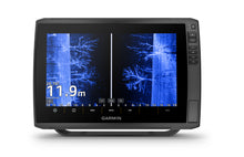
Superior Display for Any Conditions
The expansive 12.1-inch diagonal WXGA IPS display offers 1280 x 800 pixel resolution, ensuring every detail pops even under direct sunlight. With touchscreen controls enhanced by physical keys, operation stays intuitive with wet hands or gloves. Its IPX7 waterproof rating means it shrugs off splashes, rain, or accidental submersion, built tough for real-world marine adventures.
Advanced Navigation with Multi-Band Precision
Track your position with confidence using built-in multi-band GPS, GLONASS, Galileo, and BeiDou support at 10 Hz refresh rates. This setup delivers pinpoint accuracy, crucial for tight maneuvers or marking productive fishing spots. Auto Guidance+ helps plot safe, efficient routes around obstacles, while support for up to 5,000 waypoints, 50 tracks, and 100 routes keeps your favorite locations organized.
Expand your horizons with optional maps like Garmin Navionics Vision+, LakeVü g3 Ultra, or BlueChart g3 Vision. Add high-res relief shading and satellite overlays for a lifelike view of underwater contours and coastal features. Garmin QuickDraw Contours lets you create personalized HD maps on the fly, crowdsourcing data from fellow boaters via the ActiveCaptain app.
Versatile Sonar Ready for Live Action
Built-in scanning sonar capabilities shine with ClearVü and SideVü at frequencies up to 1200 kHz, revealing fish-holding structures in crystal-clear detail. Traditional CHIRP sonar covers low, medium, and high ranges (70/83/200 kHz) with 600 watts RMS power, separating targets from clutter effortlessly. Pair it with LiveScope or Panoptix transducers (sold separately) for real-time forward, down, or live-scanning views—perfect for watching fish react to your lure.
High-contrast color palettes make interpreting sonar returns a breeze, helping distinguish bait schools from game fish or spotting submerged wrecks. Record sonar screenshots to relive epic moments and share them wirelessly with your crew.
Seamless Connectivity and Networking
Stay connected with dual Garmin Marine Network ports, NMEA 2000/0183 compatibility, ANT+, and Wi-Fi. Wirelessly share sonar data, waypoints, and routes between compatible units—no cables needed. Sync with the ActiveCaptain app for software updates, community insights, and cloud storage of your maps and tracks.
| Feature | Details |
|---|---|
| NMEA 2000 Ports | 1 |
| Marine Network Ports | 2 (large connector) |
| Transducer Ports | 12-pin scanning sonar |
| Power Input | 9-18 Vdc (typ. 2.5A at 12V) |
Rugged Build for Everyday Reliability
Measuring 13.4 x 9.0 x 3.9 inches and weighing 5.5 lbs, it mounts easily via bail or flush options with a quick-release cradle. Dual microSD slots handle maps and user data up to 32GB each. Power efficiency keeps it running all day on standard 12V systems.
What's Ready to Install
- Main unit with protective sun cover
- Power/data cable
- Bail mount kit
- 8-pin to 12-pin transducer adapter
- Full hardware and docs
Frequently Asked Questions
Does this chartplotter come with a transducer?
No, it ships without a transducer, giving you flexibility to choose LiveScope, Panoptix, or other compatible options based on your needs.
What mapping is pre-loaded?
It includes a worldwide basemap with Auto Guidance+ ready for global navigation, plus slots for adding Garmin Navionics+, LakeVü, or BlueChart premium charts.
Can it network with other Garmin devices?
Yes, share sonar, waypoints, and routes wirelessly with other ECHOMAP Ultra 2 or UHD2 units via one-to-one connections.
Is the display suitable for bright sunlight?
Absolutely—the sunlight-readable IPS panel with high contrast ensures clear views, even on the sunniest days.
What sonar frequencies does it support?
Built-in CHIRP traditional (70/83/200 kHz), ClearVü and SideVü up to 1200 kHz, plus full compatibility with LiveScope and Panoptix systems.
How do I mount it on my boat?
It supports bail mounting with quick-release or flush installation, including all necessary hardware for straightforward setup.
Does it support QuickDraw Contours?
Yes, create custom HD contour maps in real-time and share them through the ActiveCaptain community.
Garmin ECHOMAP™ Ultra 2 122sv 12"" Chartplotters without Transducer
Model: 010-02881-00- SUPPORTS LIVESCOPE™ SONAR1 AND MORE
- WIRELESSLY NETWORK; SHARE SONAR, WAYPOINTS AND ROUTES2
- CAPTURE SCREEN RECORDINGS TO SHARE FISH CATCHES
- MULTI-BAND GPS FOR IMPROVED POSITION ACCURACY
With big, crisp, sunlight-readable touchscreen displays, these versatile chartplotters put a world of fishfinding capability at your fingertips. They’re available with built-in Garmin Navionics+™ mapping, and the transducer bundle adds Ultra High-Definition scanning sonars as well as CHIRP traditional sonar.
The ECHOMAP Ultra 2 series supports the full lineup of LiveScope live-scanning sonar products (transducers sold separately).
High-contrast vivid scanning sonar color palettes make it easier than ever to distinguish targets and structure.
Bring a fresh new look and feel to your chartplotter with optional Garmin Navionics Vision+™ premium mapping (sold separately), featuring high-resolution relief shading, satellite imagery and more.
If you have another compatible ECHOMAP Ultra 2 or ECHOMAP UHD2 chartplotter on your boat, you can wirelessly share information — such as sonar, waypoints and routes — with them.
LiveScope™ System sonar transducer sold separately Via one-to-one unit wireless connection only LiveScope sonar cannot be shared wirelessly between two ECHOMAP Ultra 2 or ECHOMAP UHD2 chartplotters Requires the ActiveCaptain app on your compatible smartphone paired to your ECHOMAP Ultra 2 series chartplotter
Specifications| General | |
| DIMENSION | 13.4"" x 9.0"" x 3.9"" (34.1 x 22.9 x 9.8 cm) |
| WEIGHT | 5.5 lbs (2.5 kg) |
| WATERPROOF | IPX7 |
| TOUCHSCREEN | Yes |
| DISPLAY TYPE | WXGA, IPS |
| DISPLAY SIZE | 10.3"" x 6.4""; 12.1"" diagonal (26.1 x 16.3 cm; 30.7 cm diagonal) |
| DISPLAY RESOLUTION | 1280 x 800 pixels |
| MOUNTING OPTIONS | Bail or flush |
| INPUT | Touchscreen with Keyed Assist |
| Maps & Memory | |
| ACCEPTS DATA CARDS | 2 microSD cards |
| WAYPOINTS | 5000 |
| TRACK POINTS | 50,000 |
| TRACKS | 50 saved tracks |
| NAVIGATION ROUTES | 100 |
| Sensors | |
| GPS | Yes |
| GLONASS | Yes |
| GALILEO | Yes |
| BEIDOU | Yes |
| HAS BUILT-IN RECEIVER | Yes |
| RECEIVER | 10 Hz |
| NMEA 2000 COMPATIBLE | Yes |
| NMEA 0183 COMPATIBLE | Yes |
| SUPPORTS WAAS | Yes |
| SUPPORTS MULTI-BAND, MULTI-CONSTELLATION GPS | Yes |
| Built-in Maps | |
| BUILT-IN AUTO GUIDANCE+ | Yes |
| GARMIN NAVIONICS+ INLAND & COASTAL | No |
| TIDE TABLES | No |
| Optional Map Support | |
| BLUECHART G3 | Yes |
| BLUECHART G3 VISION | Yes |
| LAKEVü G3 | Yes |
| LAKEVü G3 ULTRA | Yes |
| GARMIN NAVIONICS+™ | Yes |
| GARMIN NAVIONICS VISION+™ | Yes |
| TOPO 100K | Yes |
| STANDARD MAPPING | Yes |
| GARMIN QUICKDRAW CONTOURS | Yes |
| Electrical Features | |
| POWER INPUT | 9 to 18 Vdc |
| TYPICAL CURRENT DRAW AT 12 VDC | 2.5 A |
| MAXIMUM CURRENT DRAW AT 12 VDC | 5.0 A |
| MAXIMUM POWER USAGE AT 10 VDC | 36 W |
| Connections | |
| NMEA 2000® PORTS | 1 |
| GARMIN MARINE NETWORK PORTS | 2 (large connector) |
| 12-PIN TRANSDUCER PORTS | 12-pin scanning sonar |
| ANT+ (CONNECTIVITY) | Yes |
| GARMIN WI-FI NETWORK (LOCAL CONNECTION) | Yes |
| Sonar Features | |
| DISPLAYS SONAR | Yes |
| POWER OUTPUT | 600 watt |
| TRADITIONAL SONAR (DUAL FREQUENCY/BEAM) | built-in (single channel CHIRP, 70/83/200 kHz, L, M, H CHIRP) |
| CLEARVü | built-in 260/455/800/1000/1200 kHz |
| SIDEVü | built-in 260/455/800/1000/1200 kHz |
| PANOPTIX™ SONAR | Yes |
| LIVESCOPE | Yes |
What's in the Box:
- ECHOMAP Ultra 122sv
- Power/data cable
- Bail mount with quick release cradle
- Protective sun cover
- 8-pin transducer to 12-pin sounder adapter cable
- Hardware
- Documentation
Buy with the best price Garmin ECHOMAP Ultra 2 122sv Worldwide Basemap No Transducer for only $2899 from NVN Marine! Same day free shipping before 3pm.
Garmin ECHOMAP Ultra 2 122sv Worldwide Basemap No Transducer Technical Specifications
| Type: | |
|---|---|
| Vendor: |
Garmin |
| Weight: |
11.5 lb |
Garmin ECHOMAP Ultra 2 122sv Worldwide Basemap No Transducer User Reviews
Garmin ECHOMAP Ultra 2 122sv Worldwide Basemap No Transducer Shipping & Return
| Shipping Weight: |
11.5 lb |
|---|---|
| Box Sizes: |
1.00 (h) x 1.00 (w) x 1.00 (l) |
| Cubic Feet: |
1.0 |
| Returnable: |
Yes |
| USPS First Class: |
Yes |
| P65: |
Yes |
| Truck Delivery: |
Yes |
For detailed shipping policy please check our Shipping Policy and you can find our Return and Refund Policy here.