
Garmin ECHOMAP Ultra 2 106sv US and Coastal Canada GN+ No Transducer
Free Ground Shipping (2-6 Days Delivery Time)

Shipping (3PM)
Within 30 days
Garmin ECHOMAP Ultra 2 106sv US and Coastal Canada GN+ No Transducer Product Description
Discover Unmatched Clarity on the Water with the Garmin ECHOMAP Ultra 2 106sv
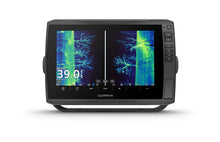
Picture this: you're out on the water at dawn, the mist rising off the lake, and your chartplotter lights up with razor-sharp images of structure below and fish darting in real time. The Garmin ECHOMAP Ultra 2 106sv delivers that experience without a transducer included, giving you the flexibility to pair it with your preferred sonar setup. This 10-inch powerhouse combines a brilliantly vivid touchscreen with preloaded Garmin Navionics+ mapping for U.S. inland and coastal waters, making it a go-to for serious anglers chasing bass in shallow bays or navigating coastal inlets with confidence.
What sets it apart? High-contrast color palettes that make targets pop against the background, whether you're interpreting SideVü scans or traditional CHIRP returns. Anglers rave about how it transforms guesswork into precision, helping you pinpoint hotspots faster and fill the livewell more efficiently.
Superior Display for Sunlit Adventures
The 10-inch WXGA IPS touchscreen (1280 x 800 resolution) shines even under the harshest sunlight, with an anti-glare surface that keeps details crisp. Measuring 8.5" x 5.4" diagonally, it's large enough for split-screen views—charts on one side, sonar on the other—without overwhelming your helm. Touchscreen controls with keyed assist mean glove-friendly operation, and the flush or bail mounting options adapt to any boat setup, from bass rigs to center consoles.
Pro tip: Capture screenshots of epic catches or custom contours directly from the screen and share them wirelessly via the ActiveCaptain app, turning your outings into brag-worthy stories.
Advanced Mapping and Navigation That Guides You True
Preloaded with Garmin Navionics+ U.S. Inland & Coastal charts, this unit includes Auto Guidance+ for intelligent route plotting that avoids low bridges and shallow hazards. Multi-band GPS (including GLONASS, Galileo, and BeiDou) with 10 Hz refresh delivers pinpoint accuracy—even in tricky harbors or crowded marinas—while supporting WAAS for sub-meter precision.
Expand your library with optional Garmin Navionics Vision+ for satellite overlay and high-res relief shading, or use QuickDraw Contours to community-crowdsource your own HD maps. Store up to 5,000 waypoints, 50 tracks with 50,000 points, and 100 routes, so your favorite honey holes stay safe and sound on dual microSD slots.
Sonar Ready for Your Next Big Catch
Built tough with IPX7 waterproofing (survives 1 meter submersion for 30 minutes), the ECHOMAP Ultra 2 106sv is sonar central. It supports LiveScope for real-time live-scanning views, Panoptix for forward-facing sweeps, ClearVü (260/455/800/1000/1200 kHz), SideVü, and single-channel CHIRP traditional sonar at 600W RMS power. No transducer means you choose the perfect match for your vessel—pair it with GT56UHD or LiveScope LVS34 for game-changing detail.
Fishermen love the vivid palettes that separate fish from weeds effortlessly, and the built-in capabilities mean clearer arches and sharper separation than entry-level units.
Seamless Connectivity and Networking
Wireless networking lets you share sonar images, waypoints, and routes between compatible ECHOMAP Ultra 2 or UHD2 units on your boat—one-to-one connections keep everyone on the same page during tournaments. NMEA 2000 and 0183 compatibility integrate with engines, autopilots, and sensors, while Garmin Marine Network ports (two large connectors) and ANT+ expand your ecosystem.
Pair with the ActiveCaptain app for software updates, community data, and smart notifications—your chartplotter stays current without a computer. Wi-Fi local networking tops it off for effortless expansion.
Reliable Power and Build for Everyday Use
Dimensions of 11.6" x 7.7" x 3.9" and a sturdy 4.0 lb build fit neatly on most dashes. It draws 2.3A typical at 12VDC (up to 5A max, 34W at 10V), powering up from 9-18 VDC sources like batteries or alternators. Connections include a 12-pin scanning sonar port, NMEA 2000, and transducer adapter cable for easy upgrades.
What's Included to Get You Started
- ECHOMAP Ultra 106sv with Garmin Navionics+ U.S. Inland & Coastal Mapping
- Power/data cable for straightforward wiring
- Bail mount with quick-release cradle for secure, removable setup
- Protective sun cover to shield from UV and spray
- 8-pin to 12-pin transducer adapter cable
- Mounting hardware and full documentation
Frequently Asked Questions
Does the Garmin ECHOMAP Ultra 2 106sv come with a transducer?
No, this model ships without a transducer, allowing you to select the ideal one for your boat and fishing style, such as LiveScope or GT series.
What mapping is preloaded on this chartplotter?
It includes Garmin Navionics+ U.S. Inland & Coastal Mapping, with Auto Guidance+ for safe routing and options to add Vision+ or QuickDraw Contours.
Is it compatible with LiveScope sonar?
Yes, it fully supports LiveScope systems (transducer sold separately) for real-time live-scanning sonar views, plus Panoptix, ClearVü, and SideVü.
What is the display size and resolution?
The 10-inch diagonal WXGA IPS touchscreen offers 1280 x 800 pixel resolution, sunlight-readable with high contrast for clear visuals on the water.
Can multiple units share data wirelessly?
Yes, via one-to-one wireless connections with other ECHOMAP Ultra 2 or UHD2 units, sharing sonar, waypoints, and routes—requires ActiveCaptain app for some features.
What is the waterproof rating?
IPX7 rated, meaning it withstands accidental immersion in 1 meter of water for up to 30 minutes, perfect for marine environments.
Does it support multi-constellation GPS?
Absolutely, with multi-band GPS, GLONASS, Galileo, BeiDou, and 10 Hz receiver for exceptional position accuracy in challenging conditions.
Why Anglers Choose the ECHOMAP Ultra 2 106sv
From weekend warriors to tournament pros, this chartplotter earns loyalty for its blend of power, portability, and performance. It simplifies complex waters, reveals hidden fish, and keeps you connected—elevating every trip. Ready to upgrade your electronics? This is the versatile foundation for bigger catches and safer passages.
Garmin ECHOMAP™ Ultra 2 106sv 10"" Chartplotters without Transducer; Includes Garmin Navionics+™ U.S. Inland & Coastal Mapping
Model: 010-02880-00- SUPPORTS LIVESCOPE™ SONAR1 AND MORE
- WIRELESSLY NETWORK; SHARE SONAR, WAYPOINTS AND ROUTES2
- CAPTURE SCREEN RECORDINGS TO SHARE FISH CATCHES
- MULTI-BAND GPS FOR IMPROVED POSITION ACCURACY
With big, crisp, sunlight-readable touchscreen displays, these versatile chartplotters put a world of fishfinding capability at your fingertips. They’re available with built-in Garmin Navionics+™ mapping, and the transducer bundle adds Ultra High-Definition scanning sonars as well as CHIRP traditional sonar.
The ECHOMAP Ultra 2 series supports the full lineup of LiveScope live-scanning sonar products (transducers sold separately).
High-contrast vivid scanning sonar color palettes make it easier than ever to distinguish targets and structure.
Bring a fresh new look and feel to your chartplotter with optional Garmin Navionics Vision+™ premium mapping (sold separately), featuring high-resolution relief shading, satellite imagery and more.
If you have another compatible ECHOMAP Ultra 2 or ECHOMAP UHD2 chartplotter on your boat, you can wirelessly share information — such as sonar, waypoints and routes — with them.
LiveScope™ System sonar transducer sold separately Via one-to-one unit wireless connection only LiveScope sonar cannot be shared wirelessly between two ECHOMAP Ultra 2 or ECHOMAP UHD2 chartplotters Requires the ActiveCaptain app on your compatible smartphone paired to your ECHOMAP Ultra 2 series chartplotter
Specifications| General | |
| DIMENSION | 11.6"" x 7.7"" x 3.9"" (29.5 x 19.5 x 9.8 cm) |
| WEIGHT | 4.0 lbs (1.8 kg) |
| WATERPROOF | IPX7 |
| TOUCHSCREEN | Yes |
| DISPLAY TYPE | WXGA, IPS |
| DISPLAY SIZE | 8.5"" x 5.4""; 10"" diagonal (21.7 x 13.6 cm; 25.4 cm diagonal) |
| DISPLAY RESOLUTION | 1280 x 800 pixels |
| MOUNTING OPTIONS | Bail or flush |
| INPUT | Touchscreen with Keyed Assist |
| Maps & Memory | |
| ACCEPTS DATA CARDS | 2 microSD cards |
| WAYPOINTS | 5000 |
| TRACK POINTS | 50,000 |
| TRACKS | 50 saved tracks |
| NAVIGATION ROUTES | 100 |
| Sensors | |
| GPS | Yes |
| GLONASS | Yes |
| GALILEO | Yes |
| BEIDOU | Yes |
| HAS BUILT-IN RECEIVER | Yes |
| RECEIVER | 10 Hz |
| NMEA 2000 COMPATIBLE | Yes |
| NMEA 0183 COMPATIBLE | Yes |
| SUPPORTS WAAS | Yes |
| SUPPORTS MULTI-BAND, MULTI-CONSTELLATION GPS | Yes |
| Built-in Maps | |
| BUILT-IN AUTO GUIDANCE+ | Yes |
| GARMIN NAVIONICS+ INLAND & COASTAL | Garmin Navionics+™ U.S. Inland & Coastal Mapping |
| TIDE TABLES | yes |
| Optional Map Support | |
| BLUECHART G3 | Yes |
| BLUECHART G3 VISION | Yes |
| LAKEVü G3 | Yes |
| LAKEVü G3 ULTRA | Yes |
| GARMIN NAVIONICS+™ | Yes |
| GARMIN NAVIONICS VISION+™ | Yes |
| TOPO 100K | Yes |
| STANDARD MAPPING | Yes |
| GARMIN QUICKDRAW CONTOURS | Yes |
| Electrical Features | |
| POWER INPUT | 9 to 18 Vdc |
| TYPICAL CURRENT DRAW AT 12 VDC | 2.3 A |
| MAXIMUM CURRENT DRAW AT 12 VDC | 5.0 A |
| MAXIMUM POWER USAGE AT 10 VDC | 34 W |
| Connections | |
| NMEA 2000® PORTS | 1 |
| GARMIN MARINE NETWORK PORTS | 2 (large connector) |
| 12-PIN TRANSDUCER PORTS | 12-pin scanning sonar |
| ANT+ (CONNECTIVITY) | Yes |
| GARMIN WI-FI NETWORK (LOCAL CONNECTION) | Yes |
| Sonar Features | |
| DISPLAYS SONAR | Yes |
| POWER OUTPUT | 600 watt |
| TRADITIONAL SONAR (DUAL FREQUENCY/BEAM) | built-in (single channel CHIRP, 70/83/200 kHz, L, M, H CHIRP) |
| CLEARVü | built-in 260/455/800/1000/1200 kHz |
| SIDEVü | built-in 260/455/800/1000/1200 kHz |
| PANOPTIX™ SONAR | Yes |
| LIVESCOPE | Yes |
What's in the Box:
- ECHOMAP Ultra 106sv; Includes Garmin Navionics+™ U.S. Inland & Coastal Mapping
- Power/data cable
- Bail mount with quick release cradle
- Protective sun cover
- 8-pin transducer to 12-pin sounder adapter cable
- Hardware
- Documentation
Buy with the best price Garmin ECHOMAP Ultra 2 106sv US and Coastal Canada GN+ No Transducer for only $2099 from NVN Marine! Same day free shipping before 3pm.
Garmin ECHOMAP Ultra 2 106sv US and Coastal Canada GN+ No Transducer Technical Specifications
| Type: | |
|---|---|
| Vendor: |
Garmin |
| Weight: |
9.4 lb |
Garmin ECHOMAP Ultra 2 106sv US and Coastal Canada GN+ No Transducer User Reviews
Garmin ECHOMAP Ultra 2 106sv US and Coastal Canada GN+ No Transducer Shipping & Return
| Shipping Weight: |
9.4 lb |
|---|---|
| Box Sizes: |
1.00 (h) x 1.00 (w) x 1.00 (l) |
| Cubic Feet: |
1.0 |
| Returnable: |
Yes |
| USPS First Class: |
Yes |
| P65: |
Yes |
For detailed shipping policy please check our Shipping Policy and you can find our Return and Refund Policy here.