
Garmin GPSMAP943 9 Plotter US and Canada GN+
Free Ground Shipping (2-6 Days Delivery Time)

Shipping (3PM)
Within 30 days
Garmin GPSMAP943 9 Plotter US and Canada GN+ Product Description
Experience Superior On-Water Navigation with Crystal-Clear Visibility
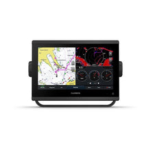
Imagine gliding through foggy mornings or battling midday glare without missing a beat on your charts. The Garmin GPSMAP 943 transforms your helm into a command center with its vibrant 9-inch in-plane switching touchscreen. Boasting 50% more pixels than earlier models, it delivers sharper details and wider viewing angles, ensuring every crew member gets a clear read from any position. Whether you're plotting a coastal cruise or dodging reefs in unfamiliar waters, this plotter's enhanced sunlight readability keeps you focused on the journey ahead.
Lightning-Fast Performance for Seamless Operation
Dual the processing power of past generations means buttery-smooth panning across detailed maps and instantaneous responses to your inputs. Paired with 10 Hz GNSS tracking across GPS, GLONASS, and Galileo, it locks onto your position with pinpoint accuracy, smoothing out speed and course-over-ground data for confident maneuvers. The slim bezels and compact footprint make retrofitting a breeze, fitting snugly into tight dash spaces without sacrificing screen real estate.
Precision Mapping That Guides You Effortlessly
Right out of the box, dive into preloaded Garmin Navionics+ charts covering U.S. and Canadian coastal and inland waters. Auto Guidance+ technology plots intelligent routes around shallows and hazards, streamlining your planning—though always pair it with vigilant seamanship. Upgrade to Vision+ for satellite overlays, high-res bathymetry, and daily updates that reveal dynamic sonar logs from the boating community.
For anglers, the integration potential shines: pair with external sonar modules for CHIRP, ClearVü, and SideVü scanning to spot structure and fish in stunning detail. Cruiser? Enjoy tide tables, weather overlays, and radar fusion for all-weather awareness.
SailAssist: Tailored Tools for Racing and Cruising Sailors
Sailors rejoice—this plotter packs advanced Garmin SailAssist features like dynamic laylines, race start-line assistance, and real-time wind angle calculations. Visualize set and drift, enhanced wind roses, and true wind data with intuitive sliders for tides and currents. Connect a compatible wind transducer to unlock heading lines, course-over-ground visuals, and more, giving you that competitive edge or relaxed passage planning.
Build Your Dream Marine Ecosystem
Seamless connectivity is at its core. NMEA 2000 and 0183 networks link autopilots, radars, cameras, multimedia, VHF, AIS, and engines—including J1939 for Yamaha and others. OneHelm consolidates third-party controls like EmpirBus digital switching onto one intuitive interface.
Wi-Fi pairs effortlessly with the ActiveCaptain app for OneChart management (switch maps without physical swaps), software updates, smart notifications, and Quickdraw Community crowdsourced contours. ANT+ opens doors to quatix watches, wireless wind sensors, GNX instruments, and remotes for hands-free control from anywhere on deck.
Rugged Build for Real-World Demands
IPX7 waterproofing shrugs off splashes, polarized lens cuts glare, and versatile mounting options (bail, flush, flat) adapt to any vessel. Power draw stays efficient at 1.3A typical, supporting extended trips without draining batteries.
Technical Specifications at a Glance
| Specification | Details |
|---|---|
| Physical Dimensions | 9.2" x 6.4" x 3" (23.3 x 16.2 x 7.6 cm) |
| Display Size | 7.8" x 4.4"; 9.0" diagonal (1280 x 720 WXGA resolution) |
| Weight | 3.6 lbs (1.6 kg) |
| Water Rating | IPX7 |
| Power Consumption | Max 22W at 10VDC; Typical 1.3A at 12VDC |
| Preloaded Maps | Garmin Navionics+ (U.S. & Canada coastal/inland) |
| Waypoints / Routes / Tracks | 5,000 / 100 / 50,000 points (50 saved) |
| Networking | NMEA 2000/0183, Garmin Marine Network, Wi-Fi, ANT+, J1939 |
| Sonar Compatibility | CHIRP, ClearVü, SideVü (external black box) |
Everything You Need to Get Started
- GPSMAP 943 chartplotter with preinstalled microSD card
- Power cable and NMEA 2000 essentials (T-connector, drop cable)
- Bail, flush, and flat mount kits with protective cover
- Documentation for quick setup
Boat owners rave about how this plotter elevates day trips into epic adventures, from family outings to tournament fishing. Its intuitive interface minimizes learning curves, letting you focus on what matters: the water.
Frequently Asked Questions
What regions do the preloaded charts cover?
The Garmin GPSMAP 943 comes preloaded with Garmin Navionics+ charts for U.S. and Canadian coastal and inland waters, including Auto Guidance+ capabilities.
Is this chartplotter suitable for sailing?
Yes, it includes built-in SailAssist features like laylines, race timers, wind data, and tide/current tools, ideal for both racing and cruising sailors.
How does it handle connectivity with other devices?
It supports NMEA 2000/0183, Garmin Marine Network, Wi-Fi for ActiveCaptain app integration, ANT+ for wearables, and J1939 for engine data.
Can I add sonar to this unit?
Absolutely—compatible with external black box sonar for CHIRP traditional, ClearVü, and SideVü scanning when paired with transducers.
What's the display like for bright conditions?
The 9-inch IPS touchscreen offers superior sunlight readability, wide-angle visibility, and 50% more pixels than previous 9-inch models for crisp charts.
Is it easy to install in existing setups?
Yes, its slim design, edge-to-edge glass, and reduced footprint allow for straightforward retrofits in various dash configurations, with multiple mounting options.
Does it support engine monitoring?
Through J1939 connectivity and OneHelm, it integrates with compatible engines and third-party devices for unified control.
Garmin GPSMAP 943 Chartplotter with U.S. and Canada Garmin Navionics+
Model: 010-02366-60- New higher-resolution in-plane switching touchscreen display offers improved sunlight readability and visibility from any angle, with 50% more pixels than previous-generation 9" units
- Fast and responsive, with nearly twice the processing power of previous-generation GPSMAP® devices, this system references 10 Hz GNSS (GPS, GLONASS and Galileo) for accurate positioning and smooth speed as well as COG data
- Slimline display borders, edge-to-edge glass and reduced unit footprint make for easy retrofit in a wider range of dash configurations
- Preloaded Garmin Navionics+™ coastal charts and inland mapping feature Auto Guidance+™ technology (Auto Guidance+ is for planning purposes only and does not replace safe navigation operations) ; plus, there’s support for optional Garmin Navionics Vision+™ premium map content.
- Built-in Garmin SailAssist™ features, including laylines, race features, set and drift, wind data and more. Requires compatible wind transducer (sold separately)
- J1939 engine connectivity for easy integration with engines and our exclusive OneHelm™ feature for connecting to your compatible third-party devices, such as EmpirBus™ digital switching
- Easily build your marine system — from compatible sonar and autopilots to compatible radar, cameras and multimedia — by using NMEA 2000® and NMEA 0183 networking and the Garmin Marine Network
- Use built-in Wi-Fi® networking to pair with the free ActiveCaptain® smartphone app for access to the OneChart™ feature, smart notifications, software updates and more.
- Integrated ANT® connectivity support for use with compatible quatix® smartwatches, the gWind™ Wireless 2 transducer, GNX™ Wind marine instrument and wireless remote controls""
With 50% more display pixels and nearly double the processing power of previous-generation 9" GPSMAP devices, this crisp touchscreen chartplotter with high-resolution IPS display integrates seamlessly into your Garmin marine system.
With its added processing power and new slimline design featuring edge-to-edge glass and a smaller unit footprint, it’s easy to retrofit this 9" plotter in a wider range of dash configurations.
New higher-resolution 9" displays offer improved sunlight readability and visibility from any angle, with 50% more pixels than previous-generation 9" GPSMAP devices.
View laylines, race start line guidance, enhanced wind rose, heading and course-over-ground lines, true wind data fields and tide/current/time slider, wind angle, set and drift, wind speed and more3.
Preloaded Garmin Navionics+™ coastal charts and inland mapping feature Auto Guidance+™ technology (Auto Guidance+ is for planning purposes only and does not replace safe navigation operations) ; plus, there’s support for optional Garmin Navionics Vision+™ premium map content.
If you have multiple compatible Garmin devices on your boat, you can share information — such as maps, user data, radar and IP camera video — among them.
Connect to compatible autopilots, digital switching, weather, Fusion-Link™ audio system, media, VHF, AIS and more from one screen.
Built-in Wi-Fi® connectivity pairs with the free all-in-one mobile app for access to the OneChart™ feature, smart notifications, software updates, Garmin Helm™ digital switching, Garmin Quickdraw™ Community data and more5.
Connect with some of your favorite devices, such as quatix® marine watches, gWind™ Wireless 2 transducers, GNX™ Wind marine instruments and wireless remote controls.
Now you can connect your chartplotter to different kinds of engines, including select Yamaha engines.
This exclusive feature brings together all the operations and capabilities of select third-party devices, such as EmpirBus™ digital switching, on one screen.
Pair with Panoptix PS51 (transducer sold separately) with FrontVü scanning sonar6 to help you see and avoid submerged obstacles in real time as you approach within a 300’ range.
Specifications| General | |
| PHYSICAL DIMENSIONS | 9.2"" x 6.4"" x 3"" (23.3 x 16.2 x 7.6 cm) |
| DISPLAY SIZE | 7.8"" x 4.4""; 9.0"" diagonal |
| DISPLAY RESOLUTION | 1280 x 720 pixels |
| DISPLAY TYPE | WXGA display |
| WEIGHT | 3.6 lbs (1.6 kg) |
| WATER RATING | IPX7 |
| POLARIZED SUPPORT | Yes |
| POWER CONSUMPTION | Max power usage at 10 Vdc: 22 W Typical current draw at 12 Vdc: 1.3 A Max current draw at 12 Vdc: 1.8 A |
| ANTENNA | Internal or external over NMEA 2000 |
| MOUNTING OPTIONS | Bail, flush or flat |
| RECEIVER | 10 Hz high-sensitivity |
| GARMIN MARINE NETWORK™ PORTS | 1 |
| Maps & Memory | |
| PRELOADED MAPS | Garmin Navionics+ offshore, coastal and inland water charts for the U.S. and Canada |
| ACCEPTS DATA CARDS | 2 microSD™ cards (back of unit) |
| WAYPOINTS | 5,000 |
| TRACK LOG | 50,000 points; 50 saved tracks |
| ROUTES | 100 |
| Outdoor Recreation | |
| TIDE TABLES | Yes |
| Chartplotter Features | |
| GARMIN RADAR COMPATIBLE | Yes |
| GARMIN SONAR COMPATIBLE | Yes (with external black box, sold separately) |
| GARMIN SMARTMODE COMPATIBLE (CUSTOMIZABLE MONITOR PRESETS) | Yes |
| SUPPORTS AIS (TRACKS TARGET SHIPS POSITION) | Yes |
| SUPPORTS DSC (DISPLAYS POSITION DATA FROM DSC-CAPABLE VHF RADIO) | Yes |
| SUPPORTS FUSION-LINK™ COMPATIBLE RADIOS | Yes |
| GSD™ BLACK BOX SONAR SUPPORT | Yes |
| GCV™ BLACK BOX SONAR SUPPORT | Yes |
| ACTIVECAPTAIN COMPATIBLE | Yes |
| GRID™ (GARMIN REMOTE INPUT DEVICE) COMPATIBLE | Yes |
| WIRELESS REMOTE COMPATIBLE | Yes |
| SAILING FEATURES | Yes |
| Sonar Features & Specifications | |
| CHIRP SONAR TECHNOLOGY | Yes (with external black box, sold separately) |
| CLEARVü | Yes (with external black box, sold separately) |
| SIDEVü | Yes (with external black box, sold separately) |
| Connections | |
| NMEA 2000® COMPATIBLE | Yes |
| NMEA 0183 INPUT PORTS | 1 (Differential) |
| NMEA 0183 OUTPUT PORTS | 1 (Differential) |
| VIDEO INPUT PORTS | 1 BNC |
| WIRELESS CONNECTIVITY | Yes |
| J1939 COMPATIBLE | Yes |
What's in the Box:
- GPSMAP 943 chartplotter Garmin Navionics+ offshore, coastal and inland water charts for the U.S. and Canada
- microSD™ card preinstalled
- Power cable
- NMEA 2000® T-connector
- NMEA 2000 drop cable (2 meters)
- Bail mount kit with knobs
- Flush mount kit with gasket
- Protective cover
- Trim piece snap covers
- Documentation
Frequently Asked Questions (FAQ) About Garmin GPSMAP943 9 Plotter US and Canada GN+
Who is the Garmin?Who is the Garmin?
Buy with the best price Garmin GPSMAP943 9 Plotter US and Canada GN+ for only $1499 from NVN Marine! Same day free shipping before 3pm.
Garmin GPSMAP943 9 Plotter US and Canada GN+ Technical Specifications
| Type: | |
|---|---|
| Vendor: |
Garmin |
| Weight: |
6.5 lb |
Garmin GPSMAP943 9 Plotter US and Canada GN+ User Reviews
Garmin GPSMAP943 9 Plotter US and Canada GN+ Shipping & Return
| Shipping Weight: |
6.5 lb |
|---|---|
| Box Sizes: |
1.00 (h) x 1.00 (w) x 1.00 (l) |
| Cubic Feet: |
1.0 |
| Returnable: |
Yes |
| USPS First Class: |
Yes |
| P65: |
Yes |
For detailed shipping policy please check our Shipping Policy and you can find our Return and Refund Policy here.