
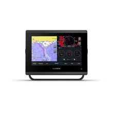
Garmin GPSMAP743 7 Plotter US and Canada GN+
Free Ground Shipping (2-6 Days Delivery Time)

Shipping (3PM)
Within 30 days
Garmin GPSMAP743 7 Plotter US and Canada GN+ Product Description
Experience Superior On-Water Navigation with Advanced Touchscreen Precision
Imagine gliding through coastal waters or inland lakes with crystal-clear charts at your fingertips, even under the brightest sun. The Garmin GPSMAP 743 elevates your boating adventures by delivering a vibrant 7-inch touchscreen that's 60% sharper than older models. Mariners from casual cruisers to serious anglers rave about its edge-to-edge glass design, which fits seamlessly into tight helm spaces while providing smooth, responsive controls for plotting routes on the fly.
Powered by a processor nearly twice as fast as previous generations, it smoothly tracks your position using 10 Hz GNSS across GPS, GLONASS, and Galileo satellites. This means rock-solid heading data and velocity updates ten times per second—crucial for dodging waves or marking that perfect fishing spot without lag.
Preloaded Charts That Guide You Smarter
Right out of the box, you'll explore detailed Garmin Navionics+ coastal and inland maps covering the US and Canada. The standout Auto Guidance+ tool crunches millions of chart points to suggest efficient paths around shallows and hazards, saving you hours of manual planning. While it's a powerhouse for trip prep, always pair it with your skipper's instincts for safe passage.
For those craving more detail, upgrade to Garmin Navionics Vision+ premium layers, unlocking high-res bathymetry, satellite overlays, and daily updates via the app. Boaters often share stories of discovering hidden coves or avoiding unmarked reefs that traditional paper charts miss entirely.
Build a Connected Helm for Every Adventure
Transform your boat into a smart command center with effortless expansion. NMEA 2000 and NMEA 0183 networks link it to sonar black boxes, radars, autopilots, cameras, and multimedia servers. J1939 engine data integration lets you monitor RPM, fuel flow, and trim tabs in one glance, while OneHelm simplifies third-party controls like digital switching.
Sailors appreciate built-in SailAssist tools: laylines for tacking angles, race countdowns, set-and-drift corrections, and wind overlays (with a compatible transducer). Add forward-scanning sonar to peer ahead at low speeds, spotting anchors or wrecks before they become problems.
- Wi-Fi pairs with the ActiveCaptain app for OneChart subscriptions, crowd-sourced intel, and quick updates.
- ANT+ links to quatix watches, wireless wind sensors, or remote controls for hands-free operation.
- Fusion-Link ready for stereo control, AIS for collision avoidance, and DSC for VHF position sharing.
Rugged Build Meets Everyday Reliability
At just 2.8 pounds with IPX7 water resistance, this compact unit (7.6 x 5.5 x 2.9 inches) withstands spray and splashes. Bail, flush, or flat mounting options adapt to any console, and polarized sunglasses compatibility ensures readability in glare. Low power draw (under 18W max) won't strain your batteries during long outings.
Store 5,000 waypoints, 50,000 track points across 50 logs, and 100 routes—plenty for multi-day trips or tournament trails. Tide tables keep you synced with currents, enhancing every cast or cruise.
Why Boaters Choose This Chartplotter for Fishing, Cruising, and Racing
Fishermen love overlaying sonar returns (via external modules) with CHIRP clarity, ClearVü for vertical detail, and SideVü for wide scans—pinpointing structure like never before. Cruisers benefit from smart notifications via app, pulling weather and marina info without leaving the helm. Racers leverage sailing features to optimize starts and legs, turning data into wins.
"It's like having a second mate who never sleeps—intuitive, fast, and packed with features that grow with your boat." – Common feedback from weekend warriors upgrading their setups.
Frequently Asked Questions
Garmin GPSMAP 743 Chartplotter with US and Canada Garmin Navionics Plus
Model: 010-02365-00- New higher-resolution touchscreen display offers improved sunlight readability with 60% more pixels than previous-generation 7" units
- Fast and responsive, with nearly twice the processing power of previous-generation GPSMAP® devices, this system references 10 Hz GNSS (GPS, GLONASS and Galileo) for accurate positioning and smooth speed as well as COG data
- Slimline display borders, edge-to-edge glass and reduced unit footprint make for easy retrofit in a wider range of dash configurations
- Preloaded Garmin Navionics+™ coastal charts and inland mapping feature Auto Guidance+™ technology (Auto Guidance+ is for planning purposes only and does not replace safe navigation operations) ; plus, there’s support for optional Garmin Navionics Vision+™ premium map content.
- Built-in Garmin SailAssist™ features, including laylines, race features, set and drift, wind data and more. Requires compatible wind transducer (sold separately)
- J1939 engine connectivity for easy integration with engines and our exclusive OneHelm™ feature for connecting to compatible third-party devices, such as EmpirBus™ digital switching
- Easily build your marine system — from compatible sonar and autopilots to compatible radar, cameras and multimedia — by using NMEA 2000® and NMEA 0183 networking and the Garmin Marine Network
- Use built-in Wi-Fi® networking to pair with the free ActiveCaptain®smartphone app for access to the OneChart™ feature, smart notifications, software updates and more.
- Integrated ANT® connectivity support for use with compatible quatix® smartwatches, the gWind™ Wireless 2 transducer, GNX™ Wind marine instrument and wireless remote controls (sold separately)""
Get a sharper view from your connected helm with the GPSMAP® 743 chartplotter. Its higher-resolution 7" display has 60% more pixels than previous-generation chartplotters. The ultrasleek design with nearly double the processing power of previous-generation GPSMAP devices offers seamless integration into your Garmin marine system. Preloaded Garmin Navionics+™ coastal charts and inland mapping feature Auto Guidance+™ technology (Auto Guidance+ is for planning purposes only and does not replace safe navigation operations. ) for confidence in helping you get where you need to go. Plus, there’s support for optional Garmin Navionics Vision+™ premium map content. Easily build your marine system — from compatible sonar and autopilots to compatible radar, cameras and multimedia — by using HTML 5.0, NMEA 2000® and NMEA 0183 networking, J1939 for engines and the Garmin Marine Network. Add FrontVü™ forward-looking sonar (sold separately) (The ability to effectively avoid forward collisions with FrontVü sonar decreases as speed rises above 8 knots ) which can help in avoiding underwater obstructions ahead. Or pair your plotter with your other compatible Garmin devices, such as quatix® marine smartwatches, wind transducers, wireless remote controls and more.c
Specifications| General | |
| PHYSICAL DIMENSIONS | 7.6"" x 5.5"" x 2.9"" (19.2 x 14.0 x 7.4 cm) |
| DISPLAY SIZE | 6.1"" x 3.5""; 7.0"" diagonal (15.4 x 9.1 cm; 17.8 cm diagonal) |
| DISPLAY RESOLUTION | 1024 x 600 pixels |
| DISPLAY TYPE | WSVGA display |
| WEIGHT | 2.8 lbs (1.3 kg) |
| WATER RATING | IPX7 |
| POLARIZED SUPPORT | Yes |
| POWER CONSUMPTION | Max power usage at 10 Vdc: 17.6 W Typical current draw at 12 Vdc: 1.1 A Max current draw at 12 Vdc: 1.5 A |
| ANTENNA | Internal or external over NMEA 2000 |
| MOUNTING OPTIONS | Bail, flush or flat |
| RECEIVER | 10 Hz high-sensitivity |
| GARMIN MARINE NETWORK™ PORTS | 1 |
| Maps & Memory | |
| PRELOADED MAPS | US and Canada Garmin Navionics+™ coastal charts and inland mapping |
| ACCEPTS DATA CARDS | 2 microSD™ cards (back of unit) |
| WAYPOINTS | 5,000 |
| TRACK LOG | 50,000 points; 50 saved tracks |
| ROUTES | 100 |
| Outdoor Recreation | |
| TIDE TABLES | Yes |
| Chartplotter Features | |
| GARMIN RADAR COMPATIBLE | Yes |
| GARMIN SONAR COMPATIBLE | Yes (with external black box, sold separately) |
| GARMIN SMARTMODE COMPATIBLE (CUSTOMIZABLE MONITOR PRESETS) | Yes |
| SUPPORTS AIS (TRACKS TARGET SHIPS POSITION) | Yes |
| SUPPORTS DSC (DISPLAYS POSITION DATA FROM DSC-CAPABLE VHF RADIO) | Yes |
| SUPPORTS FUSION-LINK™ COMPATIBLE RADIOS | Yes |
| GSD™ BLACK BOX SONAR SUPPORT | Yes |
| GCV™ BLACK BOX SONAR SUPPORT | Yes |
| ACTIVECAPTAIN COMPATIBLE | Yes |
| GRID™ (GARMIN REMOTE INPUT DEVICE) COMPATIBLE | Yes |
| WIRELESS REMOTE COMPATIBLE | Yes |
| SAILING FEATURES | Yes |
| Sonar Features & Specifications | |
| CHIRP SONAR TECHNOLOGY | Yes (with external black box, sold separately) |
| CLEARVü | Yes (with external black box, sold separately) |
| SIDEVü | Yes (with external black box, sold separately) |
| Connections | |
| NMEA 2000® COMPATIBLE | Yes |
| NMEA 0183 INPUT PORTS | 1 (Differential) |
| NMEA 0183 OUTPUT PORTS | 1 (Differential) |
| VIDEO INPUT PORTS | 1 BNC |
| WIRELESS CONNECTIVITY | Yes |
| J1939 COMPATIBLE | Yes |
What's in the Box:
- GPSMAP743 Chartplotter
- microSD preinstalled
- Power cable
- NMEA 2000 T-connector
- NMEA 2000 drop cable
- Bail mount with knobs
- Flush mount kit with gasket
- Protective cover
- Trim piece snap covers
- Documentation.
"Garmin GPSMAP743 7"" Plotter US and Canada GN+" Related Products
Garmin Quatix 7 Solar Marine GPS SmartwatchGarmin GHC50 Marine Autopilot Control Display
Frequently Asked Questions (FAQ) About Garmin GPSMAP743 7 Plotter US and Canada GN+
Who is the Garmin?Who is the Garmin?
Buy with the best price Garmin GPSMAP743 7 Plotter US and Canada GN+ for only $1199 from NVN Marine! Same day free shipping before 3pm.
Garmin GPSMAP743 7 Plotter US and Canada GN+ Technical Specifications
| Type: | |
|---|---|
| Vendor: |
Garmin |
| Weight: |
5.9 lb |
Garmin GPSMAP743 7 Plotter US and Canada GN+ User Reviews
Garmin GPSMAP743 7 Plotter US and Canada GN+ Shipping & Return
| Shipping Weight: |
5.9 lb |
|---|---|
| Box Sizes: |
1.00 (h) x 1.00 (w) x 1.00 (l) |
| Cubic Feet: |
1.0 |
| Returnable: |
Yes |
| USPS First Class: |
Yes |
| P65: |
Yes |
For detailed shipping policy please check our Shipping Policy and you can find our Return and Refund Policy here.