
Garmin GPSMAP8616 16 Plotter With US and Canada GN+
Free Ground Shipping (2-6 Days Delivery Time)

Shipping (3PM)
Within 30 days
Garmin GPSMAP8616 16 Plotter With US and Canada GN+ Product Description
Transform your boating adventures with the Garmin GPSMAP 8616, a powerhouse 16-inch chartplotter designed for captains who demand precision, clarity, and seamless control on the water. Whether you're navigating coastal waters, exploring inland lakes, or competing in sail races, this display delivers stunning visuals and smart features that keep you ahead of the curve. Preloaded with detailed Garmin Navionics+ charts covering the U.S. and Canada, it turns complex routes into effortless journeys, helping you focus on the thrill of the sea.
Superior Display for Unmatched Visibility
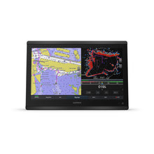
The 16-inch full HD in-plane switching (IPS) touchscreen shines in any condition, offering wide viewing angles that make it perfect for crowded helms or when wearing polarized sunglasses. Sunlight readability ensures you never miss a detail, even on the brightest days. Its anti-glare finish and edge-to-edge mounting options create a sleek, modern helm that looks as good as it performs.
Effortless Networking and Boat Integration
Build a fully connected marine ecosystem with NMEA 2000 and Garmin Marine Network support. Link radars, autopilots, sonar modules, cameras, and instruments for centralized control. ANT+ and Wi-Fi open doors to smartwatches like quatix, wireless sensors, and the ActiveCaptain app for real-time updates and community insights. OneHelm lets you command third-party devices directly from the screen, while SmartCraft Connect integration pulls engine data from up to four Mercury engines—RPM, fuel flow, temps, and more—at a glance.
Advanced Navigation with Auto Guidance+
Preloaded coastal and inland charts feature Auto Guidance+ technology, dynamically suggesting safe paths around obstacles (always pair with vigilant navigation). Upgrade to optional Vision+ for high-res satellite overlays, daily updates, and 3D views. Garmin Quickdraw Community lets you crowdsource custom maps, and SailAssist tools provide laylines, race timers, and wind data for competitive sailors chasing podium finishes.
Live Sonar and Smart Modes for Everyday Wins
Pair with the PS51 transducer for FrontVü forward-looking sonar, spotting shallows before they spot you. SmartMode presets switch setups instantly—docking mode zooms controls, fishing mode highlights sonar, cruising mode prioritizes charts. It's like having a co-pilot tailored to your activity.
Flexible Installation and Durability
At 15.1 x 10.3 x 3 inches and 9.6 lbs, it mounts flat for a glass-dash aesthetic or flush for traditional setups (pro installation recommended for edge mounts). IPX6/IPX7 water resistance laughs off spray and submersion, backed by a premium processor for lightning-fast panning and multi-screen sharing.
Detailed Specifications
| Category | Specification |
|---|---|
| Physical Dimensions | 15.1" x 10.3" x 3" (38.5 x 26.3 x 7.6 cm) |
| Weight | 9.6 lbs (4.4 kg) |
| Water Rating | IPX6 and IPX7 |
| Display | 16" IPS touchscreen (13.6" x 7.7" viewable), 1920 x 1080 FHD |
| Power Consumption | 3.5 A |
| GPS Receiver | 10 Hz GPS/GLONASS/Galileo |
| Memory | 5,000 waypoints, 100 routes (250 pts each), 50,000 track points |
| Ports | 2 Garmin Marine Network, NMEA 2000, NMEA 0183 I/O, Video (BNC/HDMI in, HDMI out), 2 microSD slots |
| Compatibilities | Radar, Sonar (CHIRP, ClearVü, SideVü), AIS, DSC, FUSION-Link, ActiveCaptain, OneHelm |
What's Included
- GPSMAP 8616 with preloaded U.S. and Canada Garmin Navionics+ charts
- Power/data cable
- NMEA 2000 drop cable and T-connector
- Flush mount kit and sun cover
- Trim piece snap covers
- Documentation
Pro Tips for Maximizing Your GPSMAP 8616
Customize SmartMode presets for your vessel's routines—save docking views with zoomed charts and engine gauges. Leverage ActiveCaptain for Quickdraw Community maps from local anglers. For sail racing, activate SailAssist early to plot perfect starts. Always cross-check Auto Guidance+ with visual navigation and local knowledge for safety.
Frequently Asked Questions
What type of charts come preloaded on the Garmin GPSMAP 8616?
It includes Garmin Navionics+ coastal and inland charts for the entire U.S. and Canada, with Auto Guidance+ for route planning.
Does the GPSMAP 8616 work with polarized sunglasses?
Yes, the IPS touchscreen provides superior sunlight readability and clarity even through polarized lenses.
Can I connect sonar or radar to this chartplotter?
Absolutely—compatible with Garmin radar, CHIRP sonar, ClearVü, SideVü, and FrontVü via black box modules or transducers.
What mounting options are available?
Supports flat edge-to-edge for a glass helm look, flush mounting, or bail with accessories (professional installation advised for custom fits).
Is it compatible with engine data from Mercury outboards?
Yes, using the SmartCraft Connect gateway, monitor up to four engines for RPM, fuel, temperature, and trim data.
How does Wi-Fi and app integration work?
Built-in Wi-Fi pairs with the ActiveCaptain app for notifications, OneChart map management, Quickdraw data, and remote planning.
What is SmartMode and how does it help?
SmartMode offers customizable presets for quick switches between docking, fishing, cruising, and anchoring screens, reducing stress in key moments.
Garmin GPSMAP8616 16"" Plotter Garmin Navionics+ coastal and inland water charts for the U.S. and Canada
Model: 010-02093-50- Features a 16" full HD in-plane switching touchscreen display for wider viewing angles, superior clarity and sunlight readability, even with polarized sunglasses
- Adds a stunning appearance with ability to install multiple displays either flat mounted edge- to-edge to create a sleek glass helm look or mounted flush
- Fully network capable with NMEA 2000® connectivity and the Garmin Marine Network to easily build your marine system — from sonar, radar and autopilots to instruments, cameras and multimedia
- ANT® connectivity and Wi-Fi® networking let you connect with your compatible quatix® smartwatches, gWind™ Wireless 2 wind sensor and more
- For full control of your boat on your chartplotter screen, use our exclusive OneHelm™ feature to connect to many third-party devices
- See RPMs, fuel flow, temperature, trim and more for up to four of your compatible Mercury® engines by using the SmartCraft® Connect gateway
- Preloaded Garmin Navionics+™ coastal charts and inland mapping feature Auto Guidance+™ technology (Auto Guidance+ is for planning purposes only and does not replace safe navigation operations) ; plus, there’s support for optional Garmin Navionics Vision+™ premium map content.
- Compatible with the live sonar PS51 transducer with FrontVü™ forward-looking sonar, which helps you avoid running aground
- SmartMode™ station controls enable presets for one-touch access to docking, cruising, fishing, anchoring and more
- Built-in Garmin SailAssist™ features provide data, displays and prerace guidance needed to gain a competitive edge
- Use built-in Wi-Fi® networking to pair with the free ActiveCaptain® smartphone app for access to the OneChart™ feature, smart notifications, Garmin Quickdraw™ Community data and more.
- Dual microSD™ card slots on back of unit for use with the ActiveCaptain® app and cartography cards
The GPSMAP®8616 chartplotter features a 16" full HD in-plane switching touchscreen display for wider viewing angles, superior clarity and sunlight readability, even with polarized sunglasses. Experience superior connectivity and networking solutions with complete control of your entire system, right at your fingertips. The device is preloaded with Garmin Navionics+™coastal charts and inland mapping that feature Auto Guidance+™technology (Auto Guidance+ is for planning purposes only and does not replace safe navigation operations). Plus, there’s support for optional Garmin Navionics Vision+™premium map content. The chartplotter includes a premium-performance processor for our fastest map drawing, superior networking, video distribution and more. Multiple displays can be flat mounted edge-to-edge to create a sleek glass helm look or mounted flush. NMEA 2000®networking and the Garmin Marine Network allow you to build your full marine electronics suite — from radar and autopilots to cameras and instruments — controlled from your chartplotter and shared across multiple screens. With SmartMode™station controls, everything is designed to give you quick, one-touch access to the information you need to ease high-stress situations such as docking. For full control of your boat on your chartplotter screen, use our exclusive OneHelm™feature to connect to many compatible third-party devices. Built-in Garmin SailAssist™features provide data, displays and prerace guidance needed to gain a competitive edge. Download the ActiveCaptain® smartphone app to your smartphone or tablet to manage your marine experience from anywhere — from trip planning and prefishing to purchasing, downloading and updating maps. See RPMs, fuel flow, temperature, trim and more for up to four of your compatible Mercury®engines by using the SmartCraft®Connect gateway.
Specifications| General | |
| Physical dimensions | 15.1"" x 10.3"" x 3"" (38.5 cm x 26.3 cm x 7.6 cm) |
| Weight | 9.6 lbs (4.4 kg) |
| Water rating | IPX6 and IPX7 |
| Display type | touchscreen IPS display (anti-glare finish) |
| Display size | 13.6"" x 7.7"" (34.5 cm x 19.5 cm) |
| Display resolution | FHD; 1920 x 1080 pixels |
| Power consumption | 3.5 A |
| Antenna | Internal or external over NMEA 2000 |
| Mounting options | Flat and flush, bail with optional accessory (Garmin does not offer any hardware or accessories for a flat-mount installation. Professional tools and knowledge is required.) |
| Receiver | 10 Hz GPS/GLONASS/Galileo |
| Garmin Marine Network™ ports | 2 |
| Maps & Memory | |
| Accepts data cards | 2 microSD cards (on back) |
| Waypoints | 5,000 |
| Routes | 100 (250 waypoints each) |
| Track log | 50,000 points; 50 saved tracks |
| pre-loaded maps | Garmin Navionics+ coastal and inland water charts for the U.S. and Canada |
| Outdoor Recreation Features | |
| Tide tables | Yes |
| Chartplotter Features | |
| Garmin Radar compatible | Yes |
| Garmin Sonar compatible | Yes |
| Garmin SmartMode compatible (customizable monitor presets) | Yes |
| Supports AIS (tracks target ships position) | Yes |
| Supports DSC (displays position data from DSC-capable VHF radio) | Yes |
| Supports FUSION-Link™ compatible radios | Yes |
| GSD™ Black Box sonar support | Yes |
| GCV™ Black Box sonar support | Yes |
| ActiveCaptain compatible | Yes |
| Garmin Helm compatible | Yes |
| GRID™ (Garmin Remote Input Device) compatible | Yes |
| Wireless remote compatible | Yes |
| Sonar Features & Specifications | |
| Dual-frequency (50/200 kHz) sonar capable | Yes (with external black box, sold separately) |
| Dual-beam (77/200 kHz) sonar capable | Yes (with external black box, sold separately) |
| Frequencies supported | NA |
| Transmit power | NA |
| CHIRP sonar technology | Yes_(when_connected_to_another_compatible_sonar_device) |
| ClearVü | yes (with GCV™ black box, sold separately) |
| SideVü | yes (with GCV™ black box, sold separately) |
| Maximum depth | NA |
| Connections | |
| NMEA 2000® compatible | Yes |
| Transducer pin numbers | na |
| NMEA 0183 input ports | 1 differential |
| NMEA 0183 output ports | 1 differential |
| Video input ports | 1 - BNC composite 1 - HDMI (HDCP compliant) |
| Video output ports | 1 HDMI |
| Wireless connectivity | Yes |
What's in the Box:
- GPSMAP 8616 Garmin Navionics+ coastal and inland water charts for the U.S. and Canada
- Power cable
- NMEA 2000® drop cable
- NMEA 2000 T-connector
- Documentation
- Flush mount kit
- Sun cover
- Trim piece snap covers
Frequently Asked Questions (FAQ) About Garmin GPSMAP8616 16 Plotter With US and Canada GN+
Who is the Garmin?Who is the Garmin?
Buy with the best price Garmin GPSMAP8616 16 Plotter With US and Canada GN+ for only $5799 from NVN Marine! Same day free shipping before 3pm.
Garmin GPSMAP8616 16 Plotter With US and Canada GN+ Technical Specifications
| Type: | |
|---|---|
| Vendor: |
Garmin |
| Weight: |
14.36 lb |
Garmin GPSMAP8616 16 Plotter With US and Canada GN+ User Reviews
Garmin GPSMAP8616 16 Plotter With US and Canada GN+ Shipping & Return
| Shipping Weight: |
14.36 lb |
|---|---|
| Box Sizes: |
1.00 (h) x 1.00 (w) x 1.00 (l) |
| Cubic Feet: |
1.0 |
| Returnable: |
Yes |
| USPS First Class: |
Yes |
| P65: |
Yes |
| Truck Delivery: |
Yes |
For detailed shipping policy please check our Shipping Policy and you can find our Return and Refund Policy here.