
Garmin GPSMAP8610 10 Plotter With US and Canada, GN+
Free Ground Shipping (2-6 Days Delivery Time)

Shipping (3PM)
Within 30 days
Garmin GPSMAP8610 10 Plotter With US and Canada, GN+ Product Description
Discover Seamless Navigation on the Water
Imagine gliding across open waters with crystal-clear charts at your fingertips, no matter the glare from the sun or the angle you're viewing from. The Garmin GPSMAP 8610 transforms your helm into a command center, blending cutting-edge display tech with robust marine networking. Anglers spot prime fishing grounds with precision sonar integration, sailors optimize race lines using built-in SailAssist tools, and casual cruisers dock effortlessly thanks to intuitive SmartMode presets. This 10-inch powerhouse isn't just a screen—it's your reliable partner for safer, smarter voyages across U.S. and Canadian waters.
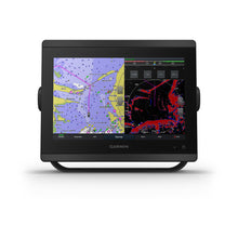
Exceptional Display for Every Condition
The edge-to-edge 10-inch full HD in-plane switching touchscreen delivers vivid WUXGA resolution (1920 x 1200 pixels) that's legible even in bright sunlight or through polarized lenses. Its anti-glare finish and wide viewing angles mean everyone on deck stays informed without straining. Mount it flush for a modern glass helm aesthetic or use the bail mount for flexibility—perfect for boats where space and style matter.
Advanced Mapping and Auto Guidance
Preloaded with detailed Garmin Navionics+ coastal and inland charts covering the U.S. and Canada, this plotter shines with Auto Guidance+ technology. It plots efficient paths around obstacles, helping you plan routes that keep your vessel safe—ideal for unfamiliar bays or busy harbors. Upgrade to Vision+ for satellite overlays, daily updates, and enhanced sonar imagery. Capture your own HD maps with Quickdraw Contours via the ActiveCaptain app, sharing data with the community for crowdsourced insights.
Full-System Integration and Control
Build a connected ecosystem with NMEA 2000, Garmin Marine Network, ANT+, and Wi-Fi. Link radars, autopilots, sonar modules like Panoptix with FrontVü forward sonar, cameras, and engines (up to four Mercury units via SmartCraft Connect for real-time RPM, fuel, and trim data). OneHelm puts third-party throttle, joystick, and VHF controls right on the screen. SmartMode stations switch instantly between docking, fishing, or cruising layouts, reducing stress in critical moments.
- Sailors benefit from Laylines, racing timers, and wind data overlays.
- Fishers pair with GCV Black Box for ClearVü and SideVü scanning.
- Cruisers enjoy Fusion-Link audio, GRID remotes, and smartwatch pairing.
Technical Specifications
| Category | Specification |
|---|---|
| General | |
| Physical dimensions | 10.25" x 8.0625" x 2.95" (25.9 x 20.5 x 7.5 cm) |
| Weight | 5.2 lbs (2.4 kg) |
| Water rating | IPX6 and IPX7 |
| Display type | Touchscreen IPS (anti-glare) |
| Display size | 8.6" x 5.4" (21.8 x 13.7 cm); 10" diagonal |
| Display resolution | WUXGA; 1920 x 1200 pixels |
| Power consumption | 2.0 A |
| Receiver | 10 Hz GPS/GLONASS/Galileo |
| Maps & Memory | |
| Waypoints | 5,000 |
| Routes | 100 (250 points each) |
| Track log | 50,000 points; 50 saved tracks |
| Preloaded maps | Garmin Navionics+ U.S. & Canada coastal/inland |
| Connections | |
| NMEA 2000 compatible | Yes |
| Garmin Marine Network ports | 2 |
| Video inputs | 1 BNC, 1 HDMI |
| Video output | 1 HDMI |
| Wireless | Wi-Fi, ANT+ |
What's Included for Easy Setup
- GPSMAP 8610 with preloaded U.S./Canada charts
- Power cable
- NMEA 2000 drop cable and T-connector
- Bail mount with knobs
- Flush mount kit
- Sun cover
- Trim piece snap covers
- Documentation
Everything you need for professional installation, though flat-mounting may require specialized tools.
Frequently Asked Questions
Garmin GPSMAP8610 10"" Plotter with Garmin Navionics+ coastal and inland water charts for the U.S. and Canada
Model: 010-02091-50- Features a 10" full HD in-plane switching touchscreen display for wider viewing angles, superior clarity and sunlight readability, even with polarized sunglasses
- Adds a stunning appearance with ability to install multiple displays either flat mounted edge- to-edge to create a sleek glass helm look or mounted flush
- Fully network capable with NMEA 2000® connectivity and the Garmin Marine Network to easily build your marine system — from sonar, radar and autopilots to instruments, cameras and multimedia
- ANT® connectivity and Wi-Fi® networking let you connect with your compatible quatix® smartwatches, gWind™ Wireless 2 wind sensor and more
- For full control of your boat on your chartplotter screen, use our exclusive OneHelm™ feature to connect to many third-party devices
- Preloaded Garmin Navionics+™ coastal charts and inland mapping feature Auto Guidance+™ technology (Auto Guidance+ is for planning purposes only and does not replace safe navigation operations); plus, there’s support for optional Garmin Navionics Vision+™ premium map content.
- See RPMs, fuel flow, temperature, trim and more for up to four of your compatible Mercury® engines by using the SmartCraft® Connect gateway
- Compatible with your Panoptix™ PS51 transducer with FrontVü™ forward-looking sonar, which helps you avoid running aground
- SmartMode™ station controls enable presets for one-touch access to docking, cruising, fishing, anchoring and more
- Built-in Garmin SailAssist™ features provide data, displays and prerace guidance needed to gain a competitive edge
- Use built-in Wi-Fi® networking to pair with the free ActiveCaptain® smartphone app for access to the OneChart™ feature, smart notifications, Garmin Quickdraw™ Community data and more.
- Dual microSD™ card slots on back of unit for use with the ActiveCaptain® app and cartography cards
The GPSMAP® 8610 chartplotter features a 10" full HD in-plane switching touchscreen display for wider viewing angles, superior clarity and sunlight readability, even with polarized sunglasses. Experience superior connectivity and networking solutions with complete control of your entire system, right at your fingertips. The device is preloaded with Garmin Navionics+™ coastal charts and inland mapping that feature Auto Guidance+™ technology (Auto Guidance+ is for planning purposes only and does not replace safe navigation operations) for helping you get where you need to go. Plus, there’s support for optional Garmin Navionics Vision+™ premium map content. GPSMAP 8610 includes a premium-performance processor for our fastest map drawing, superior networking, video distribution and more. Multiple displays can be flat mounted edge-to-edge to create a sleek glass helm look or mounted flush. NMEA 2000® networking and the Garmin Marine Network allow you to build your full marine electronics suite — from radar and autopilots to cameras and instruments — controlled from your chartplotter and shared across multiple screens. With SmartMode™ station controls, everything is designed to give you quick, one-touch access to the information you need to ease high-stress situations such as docking. For full control of your boat on your chartplotter screen, use our exclusive OneHelm™ feature to connect to many compatible third-party devices. Built-in Garmin SailAssist™ features provide data, displays and prerace guidance to help you gain a competitive edge. Download the ActiveCaptain® smartphone app to your compatible smartphone or tablet to manage your marine experience — from trip planning and prefishing to purchasing, downloading and updating maps. See RPMs, fuel flow, temperature, trim and more for up to four of your compatible Mercury® engines by using the SmartCraft® Connect gateway.
Specifications| General | |
| Physical dimensions | 10.25"" x 8.0625"" x 2.95"" (25.9 cm x 20.5 cm x 7.5 cm) |
| Weight | 5.2 lbs (2.4kg) |
| Water rating | IPX6 and IPX7 |
| Display type | touchscreen IPS display (anti-glare finish) |
| Display size | 8.6"" x 5.4"" (21.8 cm x 13.7 cm) |
| Display resolution | WUXGA; 1920 x 1200 pixels |
| Power consumption | 2.0 A |
| Antenna | Internal or external over NMEA 2000 |
| Mounting options | Bail, flat or flush (Garmin do not offer any hardware or accessories for a flat-mount installation. Professional tools and knowledge is required.) |
| Receiver | 10 Hz GPS/GLONASS/Galileo |
| Garmin Marine Network™ ports | 2 |
| Maps & Memory | |
| Accepts data cards | 2 microSD cards (on back) |
| Waypoints | 5,000 |
| Routes | 100 (250 waypoints each) |
| Track log | 50,000 points; 50 saved tracks |
| pre-loaded maps | Garmin Navionics+ coastal and inland water charts for the U.S. and Canada |
| Outdoor Recreation Features | |
| Tide tables | Yes |
| Chartplotter Features | |
| Garmin Radar compatible | Yes |
| Garmin Sonar compatible | Yes |
| Garmin SmartMode compatible (customizable monitor presets) | Yes |
| Supports AIS (tracks target ships position) | Yes |
| Supports DSC (displays position data from DSC-capable VHF radio) | Yes |
| Supports FUSION-Link™ compatible radios | Yes |
| GSD™ Black Box sonar support | Yes |
| GCV™ Black Box sonar support | Yes |
| ActiveCaptain compatible | Yes |
| Garmin Helm compatible | Yes |
| GRID™ (Garmin Remote Input Device) compatible | Yes |
| Wireless remote compatible | Yes |
| Sonar Features & Specifications | |
| Dual-frequency (50/200 kHz) sonar capable | Yes (with external black box, sold separately) |
| Dual-beam (77/200 kHz) sonar capable | Yes (with external black box, sold separately) |
| Frequencies supported | NA |
| Transmit power | NA |
| CHIRP sonar technology | Yes_(when_connected_to_another_compatible_sonar_device) |
| ClearVü | yes (with GCV™ black box, sold separately) |
| SideVü | yes (with GCV™ black box, sold separately) |
| Maximum depth | NA |
| Connections | |
| NMEA 2000® compatible | Yes |
| Transducer pin numbers | NA |
| NMEA 0183 input ports | 1 differential |
| NMEA 0183 output ports | 1 differential |
| Video input ports | 1 - BNC composite 1 - HDMI (HDCP compliant) |
| Video output ports | 1 HDMI |
| Wireless connectivity | Yes |
What's in the Box:
- GPSMAP 8610 Garmin Navionics+ coastal and inland water charts for the U.S. and Canada
- Power cable
- NMEA 2000® drop cable
- NMEA 2000 T-connector
- Bail mount with knobs
- Flush mount kit
- Sun cover
- Trim piece snap covers
- Documentation
Frequently Asked Questions (FAQ) About Garmin GPSMAP8610 10 Plotter With US and Canada, GN+
Who is the Garmin?Who is the Garmin?
Buy with the best price Garmin GPSMAP8610 10 Plotter With US and Canada, GN+ for only $2799 from NVN Marine! Same day free shipping before 3pm.
Garmin GPSMAP8610 10 Plotter With US and Canada, GN+ Technical Specifications
| Type: | |
|---|---|
| Vendor: |
Garmin |
| Weight: |
11.31 lb |
Garmin GPSMAP8610 10 Plotter With US and Canada, GN+ User Reviews
Garmin GPSMAP8610 10 Plotter With US and Canada, GN+ Shipping & Return
| Shipping Weight: |
11.31 lb |
|---|---|
| Box Sizes: |
1.00 (h) x 1.00 (w) x 1.00 (l) |
| Cubic Feet: |
1.0 |
| Returnable: |
Yes |
| USPS First Class: |
Yes |
| P65: |
Yes |
| Truck Delivery: |
Yes |
For detailed shipping policy please check our Shipping Policy and you can find our Return and Refund Policy here.