
Garmin GPSMAP1242XSV 12 Combo with GT52 Transducer US and Canada GN+
Free Ground Shipping (2-6 Days Delivery Time)

Shipping (3PM)
Within 30 days
Garmin GPSMAP1242XSV 12 Combo with GT52 Transducer US and Canada GN+ Product Description
Discover the power of seamless navigation and crystal-clear underwater views with this robust 12-inch marine chartplotter and sonar combo. Designed for serious boaters who demand precision on open water or tight inland passages, it combines advanced charting, high-definition sonar imaging, and effortless connectivity into one powerhouse unit. Whether you're chasing trophy fish along coastal stretches or plotting a perfect sail race, this setup delivers the tools to elevate every outing.
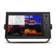
Crystal-Clear Display for Demanding Conditions
The expansive 12-inch WXGA touchscreen, paired with intuitive keypad controls and a versatile multifunction knob, ensures quick access to every feature even with wet hands or in rough seas. Its sunlight-readable brilliance cuts through glare, letting you spot distant markers or subtle bottom structures without straining. Mariners rave about how this setup transforms chaotic helm stations into organized command centers, where split-screen views juggle sonar returns, charts, and engine stats effortlessly.
Superior Sonar Imaging with Included Transducer
Right out of the box, the included GT52-TM transducer unlocks a world of detail beneath the surface. Traditional Garmin CHIRP sonar excels at marking bait schools and game fish in various water columns, while CHIRP ClearVü and SideVü scanning sonars paint photo-like images straight down and out to the sides—perfect for pinpointing structure in shallow bays or riverbeds. Dive deeper into live-action views with compatibility for all-seeing LiveScope systems, revealing fish reactions in real time as your lure dances nearby. Anglers often share stories of landing lunkers they never would have seen on basic fishfinders.
Intelligent Mapping That Adapts to You
Preloaded with detailed coastal and inland charts spanning the U.S. and Canada, this unit shines with Auto Guidance+ technology. It suggests safe paths around hazards, factoring in your vessel's draft and beam for stress-free route planning. Customize on the fly using Quickdraw Contours to generate 1-foot HD maps of your favorite honey holes, then share them community-style or keep them private. For those upgrading from older plotters, seamless GPX imports mean your hard-earned waypoints transfer without a hitch.
Stay Connected and in Control
Wireless Wi-Fi links to your smartphone via the ActiveCaptain app, streaming smart notifications, software updates, and community-sourced charts without missing a beat. Garmin Marine Network support lets you mirror data across multiple screens—sonar from one unit feeds charts on another. NMEA 2000 and 0183 compatibility integrates autopilots, weather stations, VHF radios, and AIS for collision avoidance. Monitor up to four Mercury engines' vitals like RPM, fuel flow, and trim through SmartCraft Connect. ANT+ opens doors to smartwatches and wireless wind sensors, keeping sailors dialed into laylines and true wind angles.
Tailored Features for Anglers and Sailors
Fishermen love the sonar history rewind to replay missed bites and water temp graphs for pattern spotting. Sailors benefit from SailAssist tools: virtual starting lines, synchronized race timers across networked units, set-and-drift calculations, and wind roses that maximize VMG. High-sensitivity 10 Hz GPS/GLONASS updates position 10 times per second for silky-smooth tracking, dropping 5,000 precise waypoints with ease.
Built Tough for Real-World Boating
Rated IPX7 waterproof and weighing in at a manageable 5.2 pounds, it mounts via bail or flush options to fit any console. Dual SD card slots handle map upgrades and data backups, while video input supports camera feeds for all-around awareness. Power draw stays efficient at under 35 watts, ideal for extended trips.
Easy Setup for Immediate Adventures
Everything you need arrives ready to install: power/data cables, NMEA drop cables, mounts, protective cover, and the transducer. Bail or flush mounting gets you up and running fast, with snap-on trim pieces for a clean finish. Boaters transitioning from legacy systems appreciate the straightforward networking that expands as your setup grows.
Frequently Asked Questions
What types of sonar does the included transducer support?
The GT52-TM transducer delivers Garmin CHIRP traditional sonar for excellent fish separation, plus CHIRP ClearVü for downward imaging and CHIRP SideVü for side-scanning, helping you cover more water efficiently.
Can I use this with live sonar systems?
Yes, it fully supports all-seeing LiveScope sonar transducers, providing real-time forward, downward, and perspective views of fish and structure for unmatched lure tracking.
What charts are preloaded, and can I add more?
It comes loaded with Garmin Navionics+ coastal and inland charts for the U.S. and Canada, featuring Auto Guidance+. Expand with optional Vision+ premium content via SD cards for even richer detail like satellite overlay and daily updates.
How does networking work on this unit?
With two Garmin Marine Network ports, NMEA 2000/0183 support, and Wi-Fi, you can share sonar, radar, user data, and sensors across compatible units, plus connect engines, autopilots, and media systems.
Is it suitable for sailing competitions?
Absolutely—SailAssist includes laylines, prerace guidance with virtual start lines, race timers, wind data, and set/drift tools to give racers a tactical edge.
What's the maximum depth capability?
It reaches up to 5,000 feet with 1kW power, though actual performance varies by water conditions, bottom type, and transducer setup.
Can I create and share custom maps?
Quickdraw Contours lets you map contours in real-time at 1-foot intervals, save them personally, or upload to the Quickdraw Community for others to access.
Garmin GPSMAP® 1242xsv 12-inch Chartplotter/Sonar Combo Is All-in-1 Solution with Garmin Navionics+ coastal and inland water charts for the U.S. and Canada and GT52-TM Transducer
Model: 010-01741-60- Large, bright 12" screen with keypad interface and multifunction control knob
- Includes GT52-TM transducer for Garmin CHIRP sonar and CHIRP ClearVü™ and CHIRP SideVü™ scanning sonars
- Supports all-seeing live sonar, which includes LiveScope™ sonar (transducers sold separately)
- Preloaded Garmin Navionics+™ coastal charts and inland mapping feature Auto Guidance+™ technology (Auto Guidance+ is for planning purposes only and does not replace safe navigation operations); plus, there’s support for optional Garmin Navionics Vision+™ premium map content.
- Built-in wireless capabilities for Garmin mobile apps
- See RPMs, fuel flow, temperature, trim and more for up to four of your compatible Mercury® engines by using the SmartCraft® Connect gateway
- Supports the Garmin Marine Network; allows sharing of sonar, radar, maps, user data, and NMEA 2000® and NMEA 0183 network connectivity support, including autopilots, digital switching, weather, media, VHF, AIS and other sensors
- Includes Quickdraw Contours map drawing software
- Built-in Garmin SailAssist™ features include laylines, race features, set and drift, wind data and more
- Integrated ANT® connectivity support for use with compatible quatix® smartwatches, the gWind™ Wireless 2 transducer, GNX™ Wind marine instrument and remote controls (sold separately)
Experience an advanced all-in-one solution with our 12" GPSMAP® 1242xsv keyed combo. It features a large, bright screen coupled with a keypad interface and multifunction control knob. A GT52-TM transducer is included for Garmin CHIRP sonar along with CHIRP ClearVü™ and CHIRP SideVü™ scanning sonars. There’s also support for Panoptix™ and LiveScope™ sonar products and a wide range of other transducers (sold separately). Preloaded Garmin Navionics+™ coastal charts and inland mapping feature Auto Guidance+™ technology (Auto Guidance+ is for planning purposes only and does not replace safe navigation operations). Plus, there’s support for optional Garmin Navionics Vision+™ premium map content. The combo also includes Quickdraw Contours software and the Quickdraw Community on our Garmin Connect™ online network. Use built-in Wi-Fi® technology to pair with the free ActiveCaptain® smartphone app for access to the OneChart™ feature, smart notifications, Garmin Quickdraw™ Community data and more. Garmin Marine Network support allows sharing of sonar, maps, user data, radar, IP cameras and live sonar among multiple units. Plus, there’s NMEA 2000® and NMEA 0183 network connectivity support, including autopilots, digital switching, weather, media, VHF, AIS and other sensors. These units also include integrated ANT® connectivity support for use with compatible quatix® smartwatches, the gWind™ Wireless 2 transducer, GNX™ Wind marine instrument and remote controls (sold separately). See RPMs, fuel flow, temperature, trim and more for up to four of your compatible Mercury® engines by using the SmartCraft® Connect gateway. ""
Fast, responsive built-in 10 Hz GPS and GLONASS refreshes your position and heading 10 times each second to make your movement on the screen more fluid. It makes dropping up to 5,000 accurate waypoints — and finding your way back to them — quick and easy.
Instantly create personalized HD fishing maps on screen with 1’ contours. Tailor them to fit your needs. These are your maps — you own them. Keep the data to yourself, or share it with the Quickdraw Community on our Garmin Connect™ online network.
To help you gain a wind-maximizing competitive edge, your chartplotter features a prerace guidance page that shows your virtual starting line along with data fields showing laylines, time to burn before the start and a race timer that can be synchronized across all your networked Garmin GPS products. In addition, other supported sailing features include an enhanced wind rose, heading and course-over-ground lines, set and drift, true and apparent wind data and more.
If you have waypoints, tracks or frequently used routes stored on another manufacturer’s GPS product — or on a Garmin handheld device — it’s easy to transfer those items to your new Garmin chartplotter via industry-standard GPX software formatting.
Specifications| Performance and Physical | |
| Dimensions | 14.1"" x 8.9"" x 2.7"" (35.8 x 22.6 x 6.9 cm) |
| Display size | 10.3"" x 6.4"" (26.2 x 16.3 cm) |
| Display resolution | 1280 x 800 |
| Display type | WXGA display |
| Weight | 5.2 lbs (2.34 kg) |
| Water rating | IPX7 |
| Power consumption | Max power usage at 10 Vdc: 34.8 W |
| Antenna | Internal or external over NMEA 2000 |
| Mounting options | Bail or flush |
| Receiver | 10 Hz high-sensitivity |
| Garmin Marine Network™ ports | 2 |
| Preloaded maps | Garmin Navionics+ coastal and inland water charts for the U.S. and Canada |
| Accepts data cards | 2 SD™ cards |
| Waypoints | 5,000 |
| Routes | 100 |
| Track log | 50,000 points; 50 saved tracks |
| Tide tables | Yes |
| Garmin Radar compatible | Yes |
| Garmin Sonar compatible | Yes (built-in) |
| Garmin SmartMode compatible (customizable monitor presets) | Yes |
| Supports AIS (tracks target ships position) | Yes |
| Supports DSC (displays position data from DSC-capable VHF radio) | Yes |
| Garmin Meteor™ Audio System compatible | Yes |
| Supports FUSION-Link™ compatible radios | Yes |
| GSD™ Black Box sonar support | Yes |
| GCV™ Black Box sonar support | Yes |
| ActiveCaptain compatible | Yes |
| Garmin Helm compatible | Yes |
| GRID™ (Garmin Remote Input Device) compatible | Yes |
| Wireless remote compatible | Yes |
| Dual-frequency (50/200 kHz) sonar capable | Yes |
| Dual-beam (77/200 kHz) sonar capable | Yes |
| Transmit power | 1 kW traditional; 1 kW CHIRP |
| CHIRP sonar technology | Yes (Built-in) |
| ClearVü | Yes with CHIRP (built-in) |
| SideVü | Yes with CHIRP (built-in) |
| Maximum depth | 5,000 ft at 1kW (depth capacity is dependent on water bottom type and other water conditions) |
| Bottom lock (shows return from the bottom up) | Yes |
| Water temperature log and graph | Yes |
| Sonar recording | Yes |
| Sonar history rewind | Yes |
| NMEA 2000® compatible | Yes |
| Transducer pin numbers | 12 |
| NMEA 0183 input ports | 1 |
| NMEA 0183 output ports | 1 |
| Video input ports | 1 BNC |
| Video output ports | None |
| Wireless connectivity | Yes |
What's in the Box:
- GPSMAP 1242xsv chartplotter Garmin Navionics+ coastal and inland water charts for the U.S. and Canada
- Power/data cable
- NMEA 2000 T-connector
- NMEA 2000 drop cable (2 m)
- Bail mount kit with knobs
- Flush mount kit with gasket
- Protective cover
- Trim piece snap covers
- Documentation
- GT52-TM transducer
Frequently Asked Questions (FAQ) About Garmin GPSMAP1242XSV 12 Combo with GT52 Transducer US and Canada GN+
Who is the Garmin?Who is the Garmin?
Buy with the best price Garmin GPSMAP1242XSV 12 Combo with GT52 Transducer US and Canada GN+ for only $2699 from NVN Marine! Same day free shipping before 3pm.
Garmin GPSMAP1242XSV 12 Combo with GT52 Transducer US and Canada GN+ Technical Specifications
| Type: | |
|---|---|
| Vendor: |
Garmin |
| Weight: |
12.35 lb |
Garmin GPSMAP1242XSV 12 Combo with GT52 Transducer US and Canada GN+ User Reviews
Garmin GPSMAP1242XSV 12 Combo with GT52 Transducer US and Canada GN+ Shipping & Return
| Shipping Weight: |
12.35 lb |
|---|---|
| Box Sizes: |
1.00 (h) x 1.00 (w) x 1.00 (l) |
| Cubic Feet: |
1.0 |
| Returnable: |
Yes |
| USPS First Class: |
Yes |
| P65: |
Yes |
| Truck Delivery: |
Yes |
For detailed shipping policy please check our Shipping Policy and you can find our Return and Refund Policy here.