
Garmin GPSMAP1042XSV 10 Combo Combo with GT52TM US and Canada GN+
Free Ground Shipping (2-6 Days Delivery Time)

Shipping (3PM)
Within 30 days
Garmin GPSMAP1042XSV 10 Combo Combo with GT52TM US and Canada GN+ Product Description
Discover the Power of Precision Navigation on the Water
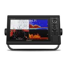
Imagine gliding across open waters with crystal-clear charts at your fingertips and real-time sonar revealing what's lurking below. The Garmin GPSMAP 1042xsv delivers that edge for serious boaters, combining a vibrant 10-inch display with advanced sonar and mapping in one rugged unit. Whether you're chasing trophy fish in freshwater lakes or navigating coastal inlets, this combo unit simplifies complex trips into confident adventures. Its intuitive keypad and control knob make adjustments effortless even with wet hands or gloves, ensuring you stay focused on the horizon.
Superior Sonar for Unmatched Fishfinding
At the heart of this system is the included GT52-TM transducer, unleashing Garmin CHIRP traditional sonar alongside ClearVü and SideVü scanning technologies. CHIRP paints sharper images of fish arches and structures, while scanning sonars provide wide-area views—SideVü sweeps left and right up to hundreds of feet, and ClearVü offers nearly photographic down views. Dive deeper with compatibility for Panoptix live sonar or LiveScope, turning your boat into a fish magnet. Real-world anglers report spotting schools in murky water that traditional sonar misses, giving you the drop on prime spots before dawn bites.
- CHIRP frequencies adapt to water conditions for detailed separation
- Scanning sonar reveals baitfish balls and wrecks in stunning detail
- Bottom lock and history rewind let you replay scans to pinpoint hotspots
- Log water temps and sonar data for pattern analysis on future outings
Preloaded Charts with Smart Guidance
Hit the water ready to go with Garmin Navionics+ charts covering U.S. and Canadian coastlines and inland waterways. Auto Guidance+ scans charts to suggest safe paths around shallows and obstacles, factoring in your vessel's draft and beam—perfect for unfamiliar bays. Sketch your own custom contours using Quickdraw Contours, then share via the Quickdraw Community for crowd-sourced intel. Upgrade to Vision+ for high-res satellite overlays and daily updates, tailoring maps to your local waters.
Seamless Connectivity for a Smarter Boat
Link up effortlessly with built-in Wi-Fi for ActiveCaptain app integration—download updates, access community data, and get smart notifications without leaving the helm. Garmin Marine Network shares sonar, radar, and cameras across multiple screens. NMEA 2000 and 0183 connect autopilots, sensors, VHF, AIS, and even engine data from up to four Mercury motors via SmartCraft Connect. ANT+ pairs with quatix watches or wireless wind sensors for a fully integrated setup.
Sailors Rejoice: Built-in SailAssist Tools
For racing crews, laylines, set/drift indicators, and wind overlays optimize tacks and starts. Track true wind angles and velocity made good to shave seconds off your finish time.
Rugged Build Meets Everyday Reliability
IPX7 water resistance shrugs off spray and splashes, while the bright WSVGA display shines under direct sun. Bail or flush mount options fit any console, and low power draw (under 3A at 12V) won't strain batteries on long days.
Detailed Specifications at a Glance
| Feature | Details |
|---|---|
| Dimensions | 12.5" x 7.3" x 2.7" (318 x 185 x 69 mm) |
| Display Size/Resolution | 8.8" x 4.9" diagonal / 1024 x 600 pixels (WSVGA) |
| Weight | 4.1 lbs |
| Water Rating | IPX7 |
| Transmit Power | 1 kW traditional; 1 kW CHIRP |
| Max Depth | 5,000 ft (conditions dependent) |
| Waypoints/Routes/Tracks | 5,000 / 100 / 50,000 points (50 saved) |
| Network Ports | 2 Garmin Marine Network; NMEA 2000/0183 |
Everything You Need to Get Started
- GPSMAP 1042xsv with preloaded U.S./Canada charts
- GT52-TM transducer
- Power/data cable and NMEA 2000 accessories
- Bail and flush mount kits
- Protective cover and documentation
Pro Tips for Maximizing Your Setup
Mount the transducer parallel to the waterline at the transom for optimal scans. Pair with a Garmin radar for all-weather safety, and use SmartMode presets to toggle views—one for trolling, another for highway cruising. Boaters love how it integrates engine vitals, alerting to issues before they strand you.
Garmin GPSMAP® 1042xsv 10-inch 10-inch Chartplotter/Sonar Combo Is All-in-1 Solution with Garmin Navionics+ coastal and inland water charts for the U.S. and Canada and GT52-TM transducer
Model: 010-01740-60- Large, bright 10" screen with keypad interface and multifunction control knob
- Includes GT52-TM transducer for Garmin CHIRP sonar and CHIRP ClearVü™ and CHIRP SideVü™ scanning sonars
- Supports Panoptix™ and LiveScope™ sonar products (transducers sold separately)
- Preloaded Garmin Navionics+™ coastal charts and inland mapping feature Auto Guidance+™ technology Auto Guidance+ is for planning purposes only and does not replace safe navigation operations; plus, there’s support for optional Garmin Navionics Vision+™ premium map content.
- Built-in wireless capabilities for Garmin mobile apps
- See RPMs, fuel flow, temperature, trim and more for up to four compatible Mercury® engines by using the SmartCraft® Connect gateway
- Supports the Garmin Marine Network; allows sharing of sonar, radar, maps, user data, and NMEA 2000® and NMEA 0183 network connectivity support, including autopilots, digital switching, weather, media, VHF, AIS and other sensors
- Includes Quickdraw Contours map drawing software
- Built-in Garmin SailAssist™ features include laylines, race features, set and drift, wind data and more
- Integrated ANT® connectivity support for use with compatible quatix® smartwatches, the gWind™ Wireless 2 transducer, GNX™ Wind marine instrument and remote controls (sold separately)
Experience an advanced all-in-one solution with our 10" GPSMAP® 1042xsv keyed combo. It features a large, bright screen coupled with a keypad interface and multifunction control knob. A GT52-TM transducer is included for Garmin CHIRP sonar along with CHIRP ClearVü™ and CHIRP SideVü™ scanning sonars. There’s also support for Panoptix™ and LiveScope™ sonar products and a wide range of other transducers (sold separately). Preloaded Garmin Navionics+™ coastal charts and inland mapping feature Auto Guidance+™ technology (Auto Guidance+ is for planning purposes only and does not replace safe navigation operations). Plus, there’s support for optional Garmin Navionics Vision+™ premium map content. The combo also includes Quickdraw Contours software and the Quickdraw Community on our Garmin Connect™ online network. Use built-in Wi-Fi® technology to pair with the free ActiveCaptain® smartphone app for access to the OneChart™ feature, smart notifications, Garmin Quickdraw™ Community data and more. Garmin Marine Network support allows sharing of sonar, maps, user data, radar, IP cameras and live sonar among multiple units. Plus, there’s NMEA 2000® and NMEA 0183 network connectivity support, including autopilots, digital switching, weather, media, VHF, AIS and other sensors. These units also include integrated ANT® connectivity support for use with compatible quatix® smartwatches, the gWind™ Wireless 2 transducer, GNX™ Wind marine instrument and remote controls (sold separately). See RPMs, fuel flow, temperature, trim and more for up to four compatible Mercury® engines by using the SmartCraft® Connect gateway.
Specifications| Performance and Physical | |
| Dimensions | 12.5"" x 7.3"" x 2.7"" (318 x 185 x 69 cm) |
| Display size | 8.8"" x 4.9"" (224 x 125 cm) |
| Display resolution | 1024 x 600 |
| Display type | WSVGA display |
| Weight | 4.1lbs |
| Water rating | IPX7 |
| Antenna | Internal or external over NMEA 2000 |
| NMEA 2000® compatible | Yes |
| NMEA 0183 compatible | Yes |
| SiriusXM™ Weather & Radio compatible | Yes |
| Power consumption | Max power usage at 10 Vdc: 32.4 W Typical current draw at 12 Vdc: 1.9 A Max current draw at 12 Vdc: 2.7 A |
| Mounting options | Bail or flush |
| Maps and Memory | |
| Preloaded maps | Garmin Navionics+ coastal and inland water charts for the U.S. and Canada |
| Accepts data card | 2 SD™ cards |
| Waypoints | 5,000 |
| Routes | 100 |
| Track log | 50,000 points; 50 saved tracks |
| Chartplotter Features | |
| Garmin Radar compatible | Yes |
| Garmin Sonar compatible | Yes (with external black box, sold separately) |
| Garmin SmartMode compatible (customizable monitor presets) | Yes |
| Supports AIS (tracks target ships position) | Yes |
| Supports DSC (displays position data from DSC-capable VHF radio) | Yes |
| Tide tables | Yes |
| Garmin Meteor Audio System compatible | Yes |
| Supports Fusion Lync compatible marine radios | Yes |
| GSD™ Black Box sonar support | Yes |
| GCV™ Black Box sonar support | Yes |
| BlueChart® Mobile (planning) compatible | Yes |
| Garmin Helm compatible | Yes |
| GRID™ (Garmin Remote Input Device) compatible | Yes |
| Wireless remote compatible | Yes |
| Connections | |
| NMEA 0183 input ports | 1 |
| NMEA 0183 output ports | 1 |
| Video input ports | 1 BNC |
| Video output ports | None |
| Wireless connectivity | Yes |
| Garmin Marine Network™ ports | 2 |
| Sonar Features and Specifications | |
| CHIRP sonar technology | Yes (Built-in) |
| ClearVü | Yes with CHIRP (built-in) |
| SideVü | Yes with CHIRP (built-in) |
| Dual-frequency (50/200 kHz) sonar capable | Yes |
| Dual-beam (77/200 kHz) sonar capable | Yes |
| Frequencies supported | Traditional: 50/77/83/200 kHz CHIRP (low, medium, high) ClearVü/SideVü (260/455/800 kHz) (dependent on transducer) |
| Transmit power | 1 kW traditional; 1 kW CHIRP |
| Maximum depth | 5,000 ft at 1kW (depth capacity is dependent on water bottom type and other water conditions) |
| Bottom lock (shows return from the bottom up) | Yes |
| Water temperature log and graph | Yes |
| Sonar recording | Yes |
| Sonar history rewind | Yes |
| Transducer port | 12-pin |
What's in the Box:
- GPSMAP 1042xsv chartplotter Garmin Navionics+ coastal and inland water charts for the U.S. and Canada
- Power/data cable
- NMEA 2000 T-connector
- NMEA 2000 drop cable (2 m)
- Bail mount kit with knobs
- Flush mount kit with gasket
- Protective cover
- Trim piece snap covers
- Documentation
- GT52-TM transducer
Garmin GPSMAP1042XSV 10 Combo Combo with GT52TM US and Canada GN+ Related Products
Garmin LiveScope™ Transducer Extension Cable - 30'Garmin LiveScope™ Transducer Extension Cable - 3'
Garmin Panoptix LiveScope XR With LVS62 Transducer and GLS 10 Sonar Black Box
Frequently Asked Questions (FAQ) About Garmin GPSMAP1042XSV 10 Combo Combo with GT52TM US and Canada GN+
Who is the Garmin?Who is the Garmin?
Buy with the best price Garmin GPSMAP1042XSV 10 Combo Combo with GT52TM US and Canada GN+ for only $1999 from NVN Marine! Same day free shipping before 3pm.
Garmin GPSMAP1042XSV 10 Combo Combo with GT52TM US and Canada GN+ Technical Specifications
| Type: | |
|---|---|
| Vendor: |
Garmin |
| Weight: |
11.17 lb |
Garmin GPSMAP1042XSV 10 Combo Combo with GT52TM US and Canada GN+ User Reviews
Garmin GPSMAP1042XSV 10 Combo Combo with GT52TM US and Canada GN+ Shipping & Return
| Shipping Weight: |
11.17 lb |
|---|---|
| Box Sizes: |
1.00 (h) x 1.00 (w) x 1.00 (l) |
| Cubic Feet: |
1.0 |
| Returnable: |
Yes |
| USPS First Class: |
Yes |
| P65: |
Yes |
| Truck Delivery: |
Yes |
For detailed shipping policy please check our Shipping Policy and you can find our Return and Refund Policy here.