


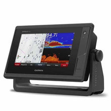
Garmin GPSMAP742XS 7 Plotter US Coastal No Transducer
It will be shipped by UPS Ground.

Shipping (3PM)
Within 30 days
Garmin GPSMAP742XS 7 Plotter US Coastal No Transducer Product Description
Unlock Precision Navigation on Your Boat
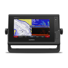
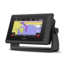
Picture this: you're cruising along the US coastline, dodging shallows and plotting the perfect course to your next anchorage. The Garmin GPSMAP 742xs makes it effortless with its vibrant 7-inch touchscreen that responds intuitively, even with wet fingers or gloves on. This compact powerhouse combines chartplotting, sonar, and networking in one sleek unit, tailored for boaters who demand reliability without the bulk.
Whether you're an angler chasing structure in coastal bays or a sailor optimizing for wind shifts, this chartplotter delivers fluid 10 Hz GPS/GLONASS tracking—refreshing your position 10 times per second for smoother trails and pinpoint waypoints. Drop up to 5,000 markers and retrace routes with confidence, all while integrating seamlessly with your boat's systems.
Crystal-Clear Sonar Without the Clutter
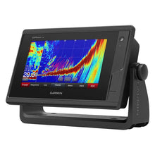
Built-in 1 kW CHIRP traditional sonar and CHIRP ClearVü scanning sonar give you stunning underwater views right away (pair with your choice of transducer for operation). Spot fish arches, bottom hardness, and structure separation like never before. Want live-action views? It supports Panoptix all-seeing sonar for real-time front-facing obstacle detection—ideal for avoiding collisions in marinas or tight spots.
Network multiple units to share sonar data across screens, overlay radar returns or GPS speed on the fishfinder view, and rewind history to revisit missed marks. For serious anglers, frequencies from 50 kHz to 800 kHz cover deep offshore drops to shallow flats, reaching up to 5,000 feet depending on conditions.
Comprehensive US Coastal and Inland Coverage
Preloaded with BlueChart g3 coastal charts and LakeVü g3 inland maps, you'll navigate over 17,000 US lakes with 1-foot contours and coastal waters featuring NOAA raster data. Auto Guidance+ tech plots safe routes around your specified depth and clearance—no more guessing with hazards.
Enhance with optional LakeVü g3 Ultra or BlueChart g3 Vision for relief shading that reveals bottom contours in vivid 3D-like detail. Features like Depth Range Shading and Shallow Water Shading highlight safe zones, while tide tables and current data keep you informed. Import GPX files from other devices for instant familiarity.
Stay Connected Across Your Vessel
Garmin Marine Network lets you share maps, sonar, radar, and IP cameras between units. NMEA 2000 and 0183 compatibility hooks up autopilots, VHF, AIS, weather stations, and FUSION-Link audio effortlessly. Built-in Wi-Fi and ANT+ connect to the ActiveCaptain app for planning, software updates, and community intel, plus quatix watches, wireless remotes, and even VIRB cameras for POV footage control.
SiriusXM weather/radio ready, SmartMode presets for customized dashboards, and GRID remote input keep everything at your fingertips. Sailing enthusiasts love the pre-race laylines, synchronized timers, wind rose, set/drift calculations, and apparent/true wind overlays.
Rugged Design for Real-World Boating
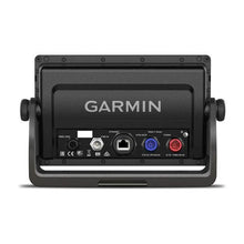
At 8.8 x 5.6 x 2.1 inches and just 1.9 lbs, it fits flush or bail mounts on consoles big or small. The IPX7 waterproof WVGA display shines in sunlight, with an internal antenna (or external via NMEA 2000). Store 100 routes, 50 tracks with 50,000 points, and dual microSD slots for expansions.
- Display: 800 x 480 multi-touch, 6.1 x 3.4-inch viewable
- Ports: 1 NMEA 2000, Garmin network, video input, differential NMEA I/O
- Extras: AIS/DSC support, tide tables, sonar recording
Ready to Mount and Go
Everything you need arrives in the box: the GPSMAP 742xs unit, power cable, bail and flush mount kits with gaskets, protective cover, trim snaps, and docs. Transducer-free for flexible installs matching your hull and needs.
Frequently Asked Questions
Does the Garmin GPSMAP 742xs include a transducer?
No, it ships without a transducer, allowing you to select the best one for your boat and fishing style, such as traditional CHIRP or ClearVü compatible models.
What types of maps come preloaded on the 742xs?
It includes BlueChart g3 for US coastal charts with NOAA data and LakeVü g3 for over 17,000 inland lakes featuring 1-foot contours and Auto Guidance+ routing.
Is the Garmin GPSMAP 742xs waterproof?
Yes, it has an IPX7 rating, protecting it from immersion up to 1 meter for 30 minutes—built tough for marine environments.
Can it connect to radar and other boat systems?
Absolutely, with Garmin Marine Network, NMEA 2000/0183, it shares data with compatible radars, AIS, autopilots, VHF, and IP cameras seamlessly.
What sonar technologies does it support?
Built-in CHIRP traditional (up to 1 kW, 5,000 ft max) and ClearVü scanning sonar, plus SideVü and Panoptix with add-ons. Frequencies include 50/77/200 kHz and CHIRP ranges.
Does it have sailing-specific features?
Yes, including pre-race guidance with laylines and timers, wind rose, set/drift, true/apparent wind, and course-over-ground lines for competitive edge.
How many waypoints and routes can it store?
Up to 5,000 waypoints, 100 routes, and 50 tracks with 50,000 points total, expandable via microSD cards.
Garmin GPSMAP® 742XS 7-inch Touchscreen Chartplotter/Sonar Combo
Model: 010-01738-03UPC: 753759168230
- 7-inch high-resolution intuitive touchscreen controls
- NMEA 2000® and NMEA 0183 support for network connectivity
- Garmin Marine Network support for sharing sonar, including Panoptix™ sonar, maps, user data, radar and IP cameras among multiple units
- Preloaded U.S. LakeVü g3 maps and BlueChart® g3 charts
Experience an advanced navigation solution with this compact 7-inch GPSMAP 742xs touchscreen combo. Includes wireless connectivity features for the Garmin BlueLink mobile app, NMEA 2000 support and Garmin Marine Network capabilities for radar and Panoptix all-seeing sonar, including Panoptix FrontVü collision avoidance sonar. It also has built-in Garmin CHIRP and CHIRP ClearVü sonar (transducer sold separately).
Full-network compatibility allows you to add more capabilities to your boat. Garmin Marine Network support allows sharing of sonar, including Panoptix sonar, maps, user data, Garmin radar, and IP cameras among multiple units. Plus, there’s NMEA 2000 and NMEA 0183 support for connectivity including autopilots, digital switching, weather, FUSION-Link, VHF, AIS and other sensors.
Enjoy built-in Wi-Fi and ANT wireless connectivity directly to quatix® marine watch, Garmin Nautix™ in-view display, gWind™ Wireless 2 transducer, GNX™ Wind marine instrument and wireless remote controls. You can even stream and control a VIRB action camera from the chartplotter.
Right out of the box, you have access to some amazing sonar capabilities; all you add are transducers. Comes with built-in Garmin 1 kW CHIRP sonar and CHIRP ClearVü scanning sonar. It even supports Panoptix all-seeing sonar, premium Garmin sonar modules and a wide range of transducers (sold separately).
Networked combos can share their internal sonar with any other device on the network. You can also choose what information is overlaid on the sonar screen, for example, radar, time of day or GPS speed.
Fast, responsive built-in 10 Hz GPS and GLONASS receiver refreshes your position and heading 10 times each second to make your movement on the screen more fluid. It makes dropping up to 5,000 accurate waypoints — and finding your way back to them — quick and easy.
LakeVü g3 inland maps and BlueChart® g3 coastal charts provide industry-leading coverage, clarity and detail with integrated Garmin and Navionics® data and Auto Guidance1 technology. LakeVü g3 and BlueChart g3 include Auto Guidance1, which uses your desired depth and overhead clearance to calculate routes and provide a suggested path to follow. LakeVü g3 provides coverage on more than 17,000 lakes with up to 1’ contours. BlueChart g3 also includes NOAA raster cartography, available as a free downloadable feature via the ActiveCaptain® app. Additionally, they both offer easy-to-use features such as Depth Range Shading and Shallow Water Shading, which let you view your target depth to avoid running aground.
Accessory map purchases, such as LakeVü g3 Ultra or BlueChart® g3 Vision, add even more features and detail to your maps and charts. LakeVü g3 Ultra and BlueChart g3 Vision add high-resolution relief shading, which provides an easy-to-interpret, clearer view of bottom structure than contour lines alone — plus many other chart and map-enhancing features.
To help you gain a wind-maximizing competitive edge, your chartplotter features a pre-race guidance page that shows your virtual starting line along with data fields showing laylines, time to burn before the start and a race timer that can be synchronized across all your networked Garmin GPS products. In addition, other supported sailing features include an enhanced wind rose, heading and course-over-ground lines, set and drift, true and apparent wind data and more.
If you have waypoints, tracks or frequently used routes stored on another manufacturer’s GPS product — or on a Garmin handheld device — it’s easy to transfer those items to your new Garmin chartplotter via industry-standard GPX software formatting.
Specifications| Physical and Performance | |
| Physcial dimensions | 8.8" x 5.6" x 2.1" (224.0mm x 142.5mm x 53.9mm) |
| Display size | 6.1" x 3.4" (154.08mm x 85.92mm) |
| Display resolution | 800 x 480 |
| Display type | Multi-touch touchscreen WVGA display |
| Weight | 1.9lbs |
| Water rating | IPX7 |
| Antenna | Internal or external over NMEA 2000 |
| NMEA2000 compatible | Yes |
| NMEA0183 compatible | Yes |
| SiriusXM™ Weather & Radio compatible | Yes |
| Mounting options | Bail or flush |
| Garmin marine network ports | 1 |
| Maps and Memory | |
| Preloaded maps | BlueChart® g3 (coastal maps) and LakeVü g3 (inland maps) |
| Accepts data cards | 2 microSD™ cards |
| Waypoints | 5,000 |
| Routes | 100 |
| Track log | 50,000 points; 50 saved tracks |
| Chartplotter Features | |
| Garmin Radar compatible | Yes |
| Garmin Sonar compatible | Yes |
| Garmin SmartMode compatible (customizable monitor presets) | Yes |
| Supports AIS (tracks target ships position) | Yes |
| Supports DSC (displays position data from DSC-capable VHF radio) | Yes |
| Tide tables | Yes |
| Garmin Meteor Audio System compatible | Yes |
| Supports Fusion Lync compatible marine radios | Yes |
| GSD™ Black Box sonar support | Yes |
| GCV™ Black Box sonar support | Yes |
| BlueChart® Mobile (planning) compatible | Yes |
| Garmin Helm compatible | Yes |
| GRID™ (Garmin Remote Input Device) compatible | Yes |
| Wireless remote compatible | Yes |
| Connections | |
| NMEA 0183 input ports | 1 (Differential) |
| NMEA 0183 output ports | 1 (Differential) |
| Video input ports | 1 BNC |
| Video output ports | None |
| Wireless connectivity | Yes |
| Sonar Features and Specifications | |
| CHIRP sonar technology | Yes (Built-in) |
| ClearVü | Yes with CHIRP (built-in) |
| SideVü | Yes (with external black box, sold separately) |
| Dual-frequency (50/200 kHz) sonar capable | Yes |
| Dual-beam (77/200 kHz) sonar capable | Yes |
| Frequencies supported | Traditional sonar (50/77/83/200 kHz), CHIRP (low, medium, high), CHIRP ClearVü (260/455/800 kHz) |
| Maximum depth | 5,000 ft at 1kW (depth capacity is dependent on water bottom type and other water conditions) |
| Bottom lock (shows return from the bottom up) | Yes |
| Water temperature log and graph | Yes |
| Sonar recording | Yes |
| Sonar history rewind | Yes |
What's in the Box:
- GPSMAP 742xs chartplotter
- Power cable
- Bail mount kit with knobs
- Flush mount kit with gasket
- Protective cover
- Trim piece snap covers
- Documentation
GARMIN GPSMAP 742xs is brand new. GARMIN GPSMAP 742xs This compact 7-inch GPSMAP 742xs touch screen combination experience advanced navigation solutions. Including wireless connectivity for the Garmin BlueLink mobile app, NMEA 2000 support, and Garmin Marine Network for radar and Panoptix full-view sonar, including PanoptixFrontVu collision avoidance sonar. It also has built-in Garmin CHIRP and CHIRPClearVu sonar (sensors sold separately).
Frequently Asked Questions (FAQ) About Garmin GPSMAP® 742XS 7-Inch Touchscreen Chartplotter/Sonar Combo
Who is the Garmin?Who is the Garmin?
Save $351 when you buy the Garmin GPSMAP742XS 7 Plotter US Coastal No Transducer for only $648 from NVN Marine! Same day shipping before 3pm.
Garmin GPSMAP742XS 7 Plotter US Coastal No Transducer Videos
Garmin GPSMAP742XS 7 Plotter US Coastal No Transducer Technical Specifications
| Type: | |
|---|---|
| Vendor: |
Garmin |
| Weight: |
4.5 lb |
Garmin GPSMAP742XS 7 Plotter US Coastal No Transducer User Reviews
Customer Reviews
Garmin GPSMAP742XS 7 Plotter US Coastal No Transducer Shipping & Return
| Shipping Weight: |
4.5 lb |
|---|---|
| Box Sizes: |
1.00 (h) x 1.00 (w) x 1.00 (l) |
| Cubic Feet: |
1.0 |
| Returnable: |
Yes |
| USPS First Class: |
Yes |
| P65: |
Yes |
For detailed shipping policy please check our Shipping Policy and you can find our Return and Refund Policy here.