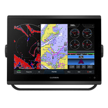
Garmin GPSMAP 1223 Non-Sonar w/Worldwide Basemap
Free Ground Shipping (2-6 Days Delivery Time)
Garmin GPSMAP 1223 Non-Sonar w/Worldwide Basemap Product Description
Transform Your Helm with Seamless Integration and Crystal-Clear Views
Imagine commanding your vessel with confidence, thanks to a chartplotter that blends cutting-edge power into a compact, modern package. The Garmin GPSMAP 1223 delivers sharper visuals on its upgraded 12-inch IPS screen, ensuring you spot critical details even under direct sunlight or from off-angles. Its slim profile with edge-to-edge glass fits effortlessly into tight dash spaces, making upgrades straightforward without major overhauls.
Whether you're cruising coastal waters or competing in regattas, this unit pulls together your entire marine ecosystem. From engine data to third-party controls, everything syncs smoothly, putting full situational awareness at your fingertips.
Superior Visibility and Build for Demanding Conditions
The WXGA resolution (1280 x 800 pixels) on a 12.1-inch diagonal display shines brighter and clearer than older models, with wide viewing angles that keep the helm team informed no matter where they stand. IPX7 water resistance means it holds up against splashes and sprays, while polarized lens support cuts glare for safer navigation.
Flexible mounting—bail, flush, or flat—adapts to any boat setup, and at just 6.6 lbs, installation feels light work.
Precision Tools for Serious Sailors
Sailors rejoice: Garmin SailAssist brings laylines, race start guidance, wind roses, and true wind overlays directly to the screen. Visualize heading, course-over-ground, set and drift, plus tide and current sliders to anticipate shifts. These aren't just gimmicks—they're game-changers for trimming sails perfectly and nailing those tacks during high-stakes races.
Pair it with worldwide basemap or upgrade to detailed charts blending Garmin and Navionics data, complete with Auto Guidance paths that simplify route planning while reminding you to stay vigilant.
Build a Unified Marine Network Effortlessly
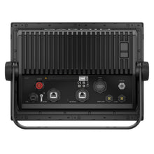
Two Garmin Marine Network ports let you share maps, radar feeds, user data, and IP camera views across compatible devices. NMEA 2000 and 0183 connect autopilots, weather stations, VHF, AIS, Fusion audio, and more—all manageable from one intuitive interface.
J1939 opens doors to diverse engines, including popular Yamaha models, while OneHelm consolidates third-party digital switching like EmpirBus. ANT+ links to quatix watches, gWind transducers, and wireless remotes for hands-free operation.
Built-in Wi-Fi hooks into the ActiveCaptain app, unlocking community-contributed Quickdraw contours, OneChart swaps, smart alerts, and over-the-air updates—keeping you connected from dock to deep water.
Expand with Radar, Sonar, and Forward-Looking Awareness
While this model skips built-in sonar, it pairs seamlessly with external black boxes for CHIRP, ClearVü, SideVü, and dual-frequency scanning. Add Panoptix with FrontVü (transducer separate) to scan 300 feet ahead, dodging reefs and wrecks in real-time.
Full radar compatibility, AIS target tracking, DSC position display, and GRID remote support round out a pro-grade setup for fog, crowds, or night runs.
Detailed Specifications at a Glance
| Category | Details |
|---|---|
| Physical Dimensions | 12.1" x 8.9" x 3.2" (30.8 x 22.8 x 8.2 cm) |
| Display | 10.3" x 6.4"; 12.1" diagonal, 1280 x 800 WXGA, IPS |
| Weight | 6.6 lbs. (3.0 kg) |
| Water Rating | IPX7 |
| Power Consumption | Max at 10 Vdc: 26.5 W; Typical at 12 Vdc: 1.7 A |
| Preloaded Maps | Worldwide basemap |
| Memory | 5,000 waypoints; 50,000 track points; 100 routes |
| Connections | 2 Marine Network ports; NMEA 2000/0183; Wi-Fi; J1939 |
Everything You Need to Get Started
- GPSMAP 1223 chartplotter
- Preinstalled microSD card
- Power cable
- NMEA 2000 T-connector and 2m drop cable
- Bail mount kit with knobs
- Flush mount kit with gasket
- Protective cover
- Trim piece snap covers
- Documentation
Ready to mount and explore right out of the package—add your charts and sensors for full potential.
Frequently Asked Questions
GPSMAP 1223 Non-Sonar with Worldwide Basemap
GET A SHARPER VIEW FROM YOUR CONNECTED HELM
With its sleek design, powerful processing, and upgraded IPS display, this advanced 12 chartplotter integrates seamlessly into your Garmin marine system.
Features:
- Easily integrate with more engines.
- Connect to compatible third-party devices with OneHelm digital switching.
- Easily build your marine system using the best network connectivity.
- Compatible with premium maps and charts1 for the best in Garmin navigation.
- Take the guesswork out of sailing with clear laylines and more right on the screen.
- Manage your marine experience from nearly anywhere2.
FASTER, SHARPER, SMARTER
With its powerful technology and new slimline design featuring edge-to-edge glass and a smaller unit footprint, it's easy to retrofit this 12 plotter in a wider range of dash configurations.
IMPROVED DISPLAY OPTICS
2 IPS displays offer improved sunlight readability and wide-angle visibility over previous-generation GPSMAP 12 Plus devices.
GARMIN SAILASSIST SAILING FEATURES
View laylines, race start line guidance, enhanced wind rose, heading and course-over-ground lines, true wind data fields and tide/current/time slider, wind angle, set and drift, wind speed, and more3.
OPTIONAL BLUECHART G3 VISION CHARTS
These optional charts offer the best of Garmin and Navionics data, Auto Guidance3 technology, and other premium navigation features.
GARMIN MARINE NETWORK
If you have multiple compatible Garmin devices on your boat, you can share information such as maps, user data, radar, and IP camera video among them.
NMEA 2000 AND NMEA 0183 NETWORKS
Connect to compatible autopilots, digital switching, weather, Fusion-Link audio system, media, VHF, AIS, and more from one screen.
ACTIVECAPTAIN APP
Built-in Wi-Fi connectivity pairs with the free all-in-one mobile app for access to the OneChart feature, smart notifications, software updates, Garmin Helm digital switching, Garmin Quickdraw Community data, and more4.
INTEGRATED ANT TECHNOLOGY
Connect with some of your favorite devices, such as quatix marine watches, gWind Wireless 2 transducers, GNX Wind marine instruments, and wireless remote controls.
J1939 CONNECTIVITY
Now you can connect your chartplotter to different kinds of engines, including select Yamaha engines.
ONEHELM FEATURE
This exclusive feature brings together all the operations and capabilities of select third-party devices, such as EmpirBus digital switching, on one screen.
PANOPTIX SONAR SUPPORT
Pair with Panoptix PS51 (transducer sold separately) with FrontV scanning sonar6 to help you see and avoid submerged obstacles in real-time as you approach within a 300' range.
What's In The Box?
- GPSMAP 1223 chartplotter
- microSD card preinstalled
- Power cable
- NMEA 2000 T-connector
- NMEA 2000 drop cable (2 meters)
- Bail mount kit with knobs
- Flush mount kit with gasket
- Protective cover
- Trim piece snap covers
- Documentation
1 Sold separately
2 Requires ActiveCaptain app on your compatible smartphone paired to the GPSMAP 723xsv
3 Auto Guidance is for planning purposes only and does not replace safe navigation operations
4 When paired with your compatible smartphone
Wi-Fi is a registered trademark of the Wi-Fi Alliance.
Garmin GPSMAP 1223 Chartplotter with Worldwide Basemap
Model: 010-02367-00- Easily integrate with more engines.
- Connect to compatible third-party devices with OneHelm™ digital switching.
- Easily build your marine system using the best of network connectivity.
- Compatible with premium maps and charts for the best in Garmin navigation.
- Take the guesswork out of sailing with clear laylines and more — right on the screen.
- Manage your marine experience from nearly anywhere2.
With its sleek design, powerful processing and upgraded IPS display, this advanced 12" chartplotter integrates seamlessly into your Garmin marine system.
With its powerful technology and new slimline design featuring edge-to-edge glass and a smaller unit footprint, it’s easy to retrofit this 12" plotter in a wider range of dash configurations.
New 12" IPS displays offer improved sunlight readability and wide-angle visibility over previous-generation GPSMAP 12" Plus devices.
View laylines, race start line guidance, enhanced wind rose, heading and course-over-ground lines, true wind data fields and tide/current/time slider, wind angle, set and drift, wind speed and more3.
These optional charts offer the best of Garmin and Navionics® data, Auto Guidance4 technology and other premium navigation features.
If you have multiple compatible Garmin devices on your boat, you can share information — such as maps, user data, radar and IP camera video — among them.
Connect to compatible autopilots, digital switching, weather, Fusion-Link™ audio system, media, VHF, AIS and more from one screen.
Built-in Wi-Fi® connectivity pairs with the free all-in-one mobile app for access to the OneChart™ feature, smart notifications, software updates, Garmin Helm™ digital switching, Garmin Quickdraw™ Community data and more5.
Connect with some of your favorite devices, such as quatix® marine watches, gWind™ Wireless 2 transducers, GNX™ Wind marine instruments and wireless remote controls.
Now you can connect your chartplotter to different kinds of engines, including select Yamaha engines.
This exclusive feature brings together all the operations and capabilities of select third-party devices, such as EmpirBus™ digital switching, on one screen.
Pair with Panoptix PS51 (transducer sold separately) with FrontVü scanning sonar6 to help you see and avoid submerged obstacles in real time as you approach within a 300’ range.
Specifications| General | |
| PHYSICAL DIMENSIONS | 12.1" x 8.9" x 3.2" (30.8 x 22.8 x 8.2 cm) |
| DISPLAY SIZE | 10.3" x 6.4"; 12.1" diagonal |
| DISPLAY RESOLUTION | 1280 x 800 pixels |
| DISPLAY TYPE | WXGA display |
| WEIGHT | 6.6 lbs. (3.0 kg) |
| WATER RATING | IPX7 |
| POLARIZED SUPPORT | Yes |
| POWER CONSUMPTION | Max power usage at 10 Vdc: 26.5 W Typical current draw at 12 Vdc: 1.7 A Max current draw at 12 Vdc: 2.2 A |
| ANTENNA | Internal or external over NMEA 2000 |
| MOUNTING OPTIONS | Bail, flush or flat |
| RECEIVER | 10 Hz high-sensitivity |
| GARMIN MARINE NETWORK™ PORTS | 2 |
| Maps & Memory | |
| PRELOADED MAPS | worldwide basemap |
| ACCEPTS DATA CARDS | 2 microSD™ cards (back of unit) |
| WAYPOINTS | 5,000 |
| TRACK LOG | 50,000 points; 50 saved tracks |
| ROUTES | 100 |
| Outdoor Recreation | |
| TIDE TABLES | Yes |
| Chartplotter Features | |
| GARMIN RADAR COMPATIBLE | Yes |
| GARMIN SONAR COMPATIBLE | Yes (with external black box, sold separately) |
| GARMIN SMARTMODE COMPATIBLE (CUSTOMIZABLE MONITOR PRESETS) | Yes |
| SUPPORTS AIS (TRACKS TARGET SHIPS POSITION) | Yes |
| SUPPORTS DSC (DISPLAYS POSITION DATA FROM DSC-CAPABLE VHF RADIO) | Yes |
| SUPPORTS FUSION-LINK™ COMPATIBLE RADIOS | Yes |
| GSD™ BLACK BOX SONAR SUPPORT | Yes |
| GCV™ BLACK BOX SONAR SUPPORT | Yes |
| ACTIVECAPTAIN COMPATIBLE | Yes |
| GRID™ (GARMIN REMOTE INPUT DEVICE) COMPATIBLE | Yes |
| WIRELESS REMOTE COMPATIBLE | Yes |
| SAILING FEATURES | Yes |
| Sonar Features & Specifications | |
| DUAL-FREQUENCY (50/200 KHZ) SONAR CAPABLE | Yes (with external black box, sold separately) |
| DUAL-BEAM (77/200 KHZ) SONAR CAPABLE | Yes (with external black box, sold separately) |
| CHIRP SONAR TECHNOLOGY | Yes (with external black box, sold separately) |
| CLEARVü | Yes (with external black box, sold separately) |
| SIDEVü | Yes (with external black box, sold separately) |
| Connections | |
| NMEA 2000® COMPATIBLE | Yes |
| NMEA 0183 INPUT PORTS | 1 |
| NMEA 0183 OUTPUT PORTS | 1 |
| VIDEO INPUT PORTS | 1 BNC |
| VIDEO OUTPUT PORTS | 1 HDMI |
| WIRELESS CONNECTIVITY | Yes |
| J1939 COMPATIBLE | Yes |
What's in the Box:
- GPSMAP 1223 chartplotter
- microSD™ card preinstalled
- Power cable
- NMEA 2000® T-connector
- NMEA 2000 drop cable (2 meters)
- Bail mount kit with knobs
- Flush mount kit with gasket
- Protective cover
- Trim piece snap covers
- Documentation
Use GPSMAP 1223 chartplotter to get a clearer view from the connected helmet. Its high-resolution 12-inch in-plane switch touch screen and ultra-stylish design seamlessly integrate it into the Garmin marine system, making your full control at your fingertips. It supports optional charts with automatic guidance technology, thereby increasing your confidence in helping you reach the desired location. Use HTML 5.0, NMEA 2000 and NMEA 0183 network connection, J1939 and Garmin navigation network for engine, easily build your navigation system (from compatible sonar and autopilot to compatible radar, camera and multimedia). Add PanoptixFrontVu forward looking sonar (sold separately) to help avoid underwater obstacles ahead. Or pair the plotter with other compatible Garmin devices, such as quatix marine smart watches, wind sensors, wireless remote controls, etc.
Garmin GPSMAP 1223 Non-Sonar w/Worldwide Basemap Related Products
Garmin Adapter Plate f/GPSMAP® 12x2 to 12x3 SeriesFrequently Asked Questions (FAQ) About Garmin GPSMAP 1223 Non-Sonar w/Worldwide Basemap
Who is the Garmin?What is the resolution of the product?
What is the weight of the product?
Who is the Garmin?
What is the resolution of the product?
- 12” display with 480 x 800 resolution
- Built-in Wi-Fi
- Integrated worldwide basemap
- Connect and control from your smartphone or tablet via Bluetooth or Wi-Fi
- 12” high-resolution display that provides a clear view of your surroundings.
- Comes with a worldwide basemap for easy navigation.
- Built-in Wi-Fi and Bluetooth for connecting to your smartphone or tablet.
- With its sleek design, powerful processing, and upgraded IPS display, this advanced 12” chartplotter integrates seamlessly into your cockpit.
- GPSMAP 1223 Non-Sonar with Worldwide Basemap offers a sharp view of the world with a high-resolution display that is easy to read from any angle.
- The boat’s position is shown on the map in relation to surrounding land and coastal features.
What is the weight of the product?
Buy with the best price Garmin GPSMAP 1223 Non-Sonar w/Worldwide Basemap for only $2899 from NVN Marine! Same day free shipping before 3pm.
Garmin GPSMAP 1223 Non-Sonar w/Worldwide Basemap Technical Specifications
| Type: | |
|---|---|
| Vendor: |
Garmin |
| Weight: |
12.1 lb |
| Cartography Brand: |
Garmin |
| Internal/External Antenna: |
Internal |
| Screen Size: |
12" |
| Touchscreen: |
Yes |
| Categories v2: |
Marine Navigation & Instruments | GPS - Chartplotters |
| Category v1: |
GPS FIXED MOUNT |
| UPC: |
753759250614 |
| Product Manual: | |
| Product Installation: |
Garmin GPSMAP 1223 Non-Sonar w/Worldwide Basemap User Reviews
Garmin GPSMAP 1223 Non-Sonar w/Worldwide Basemap Shipping & Return
| Shipping Weight: |
12.1 lb |
|---|---|
| Box Sizes: |
9.00 (h) x 17.00 (w) x 12.00 (l) |
| Cubic Feet: |
1836.0 |
| Returnable: |
Yes |
| USPS First Class: |
Yes |
| Oversize Item: |
Yes |
For detailed shipping policy please check our Shipping Policy and you can find our Return and Refund Policy here.


